Tuesday, November 30, 2021

The Australian Embassy Featured My Photo

One of the photos I have taken in the past is being featured on the Australian Embassy website! The Australian Embassy used my photo to promote the San Diego Anzac Day Service event on 25 April 2017.

A screenshot of the event page, where my photo is being featured, on the Australian Embassy website.
I normally hate using the Microsoft Edge Web Browser, but I have to admit, the full page screenshot function does come in handy sometimes. This screenshot was taken using the Microsoft Edge Web Browser.

The photo used by the Australian Embassy is a photo that I took during sunset from Tuna Harbor Park in San Diego, CA of the USS Midway Museum. I took that photo on 28 December 2014, on a family road trip to Southern California. 

The sunset photo I've taken that the Australian Embassy featured on their website.
Approximate GPS Coordinates: 32° 42' 47" N 117° 10' 25" W
Camera: Canon EOS 5D Mark III DSLR Camera | Lens: Canon EF 16-35mm f/2.8L II USM Lens
Aperture: f/16 | Exposure Time: 1/5 second | ISO: 100

Full disclosure, the Australian Embassy actually used my photo without contacting me first or giving me credit, but after I reached out to them, they gave me credit on the event page where they used my photo. I honestly feel very honoured that the Australian Embassy decided my photo is worthy of one of their event pages. I don't think a lot of photographers get to say their photo art is being featured on a government website.

Screenshots of the event page, where my photo is being featured, on the Australian Embassy website. I'm posting these screenshots because the first screenshot might be hard to read at the resolution on this blog.

You can see my photo featured on the Australian Embassy website in the screenshots above, or you can see it on their event page here. A full resolution copy of my photo can be viewed on my portfolio here. If you are looking for the blog post where I shared this photo, you can find that here.

Below are just some screenshots of the email exchanges between the Australian Embassy and I.

A screenshot of the email exchanges I had with the Australian Embassy.

You can see in the initial email, I didn't tell the Australian Embassy the exact location where my photo is being used. There is a good reason why I did not give them a direct link to the event page immediately. I was not able to find a direct contact to reach whoever is managing the event pages. I reached out to the Australian Embassy using the media contact email found on their "Media Enquiries" page. Sometimes when I email someone about copyright and ask for a credit because they used my photo, the user panics, and just removes the photo. I did not want the Australian Embassy to do that considering they've been using my photo credit free since March 2017. There are no benefits for me if the Australian Embassy just removed the photo at this point. Getting a credit on a government website would get my website and blog more visitors and attention, and possibly even boost my search engine rankings. I knew the email to their media contact wouldn't reach the right department immediately, and I didn't want whoever received that email to just completely pull the page from the Australian Embassy website.

Screenshots of the Australian Embassy event page with Google Chrome's developer tools console open.

The reason I knew the Australian Embassy has been using my photo since March 2017 is because the png file on their website is named "screen_shot_2017-03-28_at_6.40.25_pm.png". You can see it in the screenshots above as I "Inspected" the embedded image on the event page in Google Chrome.

A screenshot of the email exchanges I had with the Australian Embassy.

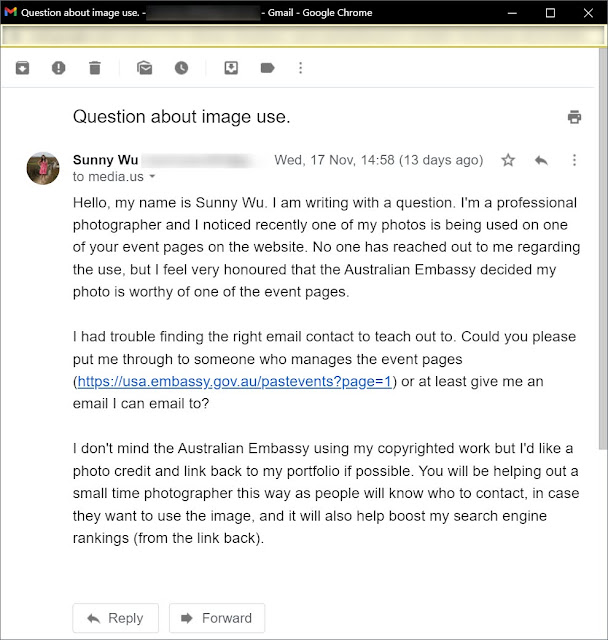
I got an email back from someone named Aimee H. who works at the Australian Embassy. She seems eager to give me a credit on the event page as long as she knew which event page it was.

A screenshot of the email exchanges I had with the Australian Embassy.

Aimee seemed really nice and was willing to give me credit, so I responded with the exact event page where my photo is being used, and also links to my website and blog to prove ownership.

A screenshot of the email exchanges I had with the Australian Embassy.

I just received word back from Aimee today that she has added a credit to the photo on the event page. It took a bit longer than usual because she was out of office for a while.

A screenshot of the email exchanges I had with the Australian Embassy.

Here is me thanking Aimee and notifying her that this matter is resolved. 

I just want to again express that I feel very honoured that the Australian Embassy chose my photo to use on their event page. I think for many photographers, having their art featured on a government website is just a dream. Thank you Australian Embassy for choosing my photo art and thank you Aimee for helping me add a photo credit to the event page.

~~ Begin Update 1 December 2021 ~~

Screenshots of the "Like" and comment the Australian Embassy in the US (@AusintheUS) left on my Tweet on Twitter.

Thank you so much to the Australian Embassy in the US (@AusintheUS) for "Liking" and leaving a comment on my Tweet on Twitter. 😁

~~ End Update 1 December 2021 ~~

Credits:
The content in the screenshots of the event page on the Australian Embassy website (with the exception of the photo that I took) are used under a Creative Commons Attribution 4.0 International license from the Embassy of Australia and the Australian Department of Foreign Affairs and Trade. More information on the license and copyright available on the Australian Department of Foreign Affairs and Trade website here. The website of the Australian Department of Foreign Affairs and Trade can be found here and the website of the Australian Embassy in the USA can be found here.

Copyright Warning: The photo that I have taken of the USS Midway Museum is one of my most popular works of art. Unauthorized usage and reproductions are strictly prohibited. Please contact me here to purchase prints and negotiate photo licenses.

Thursday, November 25, 2021

Carson-Iceberg Wilderness/Stanislaus National Forest, CA

On 28 May 2021, I took a day trip to Stanislaus National Forest in California traveling along SR-108 (my parents drove, as I can't drive anymore). I also visited Carson Iceberg Wilderness on my hike. Here are the photos I took with my mirrorless camera. You can see the cellphone photos I took here.

The photos in this blog post are taken on my attempted hike from St. Mary's Pass Trail Head to Sonora Peak via St. Mary's Pass Trail. I hiked in both Stanislaus National Forest and Carson Iceberg Wilderness. I didn't end up being able to make it up Sonora Peak as the last bit of the trail was too steep for my liking (I've been visually impaired since August 2018), and I figured it's beyond my hiking skills. I still hiked up to almost 11,000 ft (3353 m) above sea level. 

If you do want to do this hike, note that if you head up there from the San Francisco Bay Area (sea level), you will get hit with altitude sickness! I mostly had no symptoms (until I tried to run around up there), my dad was a bit worse off than I was, and my mom got moderately sick from the altitude. Learn the symptoms of altitude sickness, sometimes people might feel a bit sleepy and euphoric, and do something stupid. Altitude sickness can slow down your brain, "dumb you down", and make performing simple tasks hard. Stay safe while hiking, know your limits, and don't push yourself over your limits. I do not recommend hiking this hike alone. I'm not a medical professional, so make sure you do your own research. The information here is just based on my own experience as a wilderness photographer for over a decade.

For this hike I also recommend you bring a physical compass and learn how to use it, as it is easy to lose sight of the trail or get lost on this trail (your phone can malfunction and/or run out of power). Also hiking poles are a necessity. 

High Resolution Photos: If you want to see full resolution photos of any of the photos you see here, use the following links. If you wish to purchase prints of any of the photos, please contact me here. To view my best Stanislaus National Forest photos, use this link. To see all of my photos from this trip, use this link.

Message from the photographer: This might be the last blog post with photos I've taken on a "real camera" (not taken with my cellphone) for a while. The vision loss, due to visual snow syndrome, has made photography and traveling very challenging. These are the last of the photos in my archive that I've taken with a "real camera". I'll probably have more blog posts out with cellphone photos as those photos are more casual, my mom is sometimes helping me with those, and it doesn't require the post processing and sorting I normally do with photos I take on my "real camera". I know in the past I've mostly used cellphone photos as a filler for when I don't have anything to post, and I really don't want to turn this blog into a cellphone photos only blog, but with the vision loss, it is very hard. 

A scenery photo of Stanislaus Peak shot on St. Mary's Pass Trail in Carson-Iceberg Wilderness.
Approximate GPS location (type into Google): 38° 21' 07" N 119° 38' 57" W

The clouds looked amazing that day. California is in drought so there was very little snow in the Sierras.

A black and white process of the photo above.

A panorama from St. Mary's Pass Trail in Carson-Iceberg Wilderness.
In the photo are Stanislaus Peak (center), and Red Peak & Bald Peak (left).
Photo shot near the same position as above.

Normally in the month of May, I wouldn't be able to even hike here as there would be too much snow, but California is in drought and the Sierras isn't getting as much snow in the winter.

A black and white process of the photo above.

A scenery photo from St. Mary's Pass Trail in Stanislaus National Forest.
Photo shot near the same position as above.

A black and white process of the photo above.

A panorama from St. Mary's Pass Trail in Carson-Iceberg Wilderness.
On the right of the panorama is Night Cap Peak.
Photo shot near the same position as above.

Normally in May, the areas I've photographed would be covered with snow, but due to California's drought, there is barely any.

A black and white process of the photo above.

A scenery photo of Night Cap Peak shot from St. Mary's Pass Trail in Stanislaus National Forest.
Approximate GPS location (type into Google): 38° 21' 01" N 119° 38' 56" W

A black and white process of the photo above.

A scenery photo from St. Mary's Pass Trail in Stanislaus National Forest.
On the right of this photo is Night Cap Peak.
Photo shot near the same position as above.

A black and white process of the photo above.

A scenery photo from St. Mary's Pass Trail in Stanislaus National Forest.
In the photo are Walker Mountain & Hanging Valley Ridge (center), and Hanna Mountain (right).
Approximate GPS location (type into Google): 38° 20' 52" N 119° 38' 53" W

A black and white process of the photo above.

A scenery photo from St. Mary's Pass Trail in Stanislaus National Forest.
In the photo are Walker Mountain & Hanging Valley Ridge (center), Mt. Emma (left), Hanna Mountain (slightly right from center), and Tower Peak (right).
Approximate GPS location (type into Google): 38° 20' 40" N 119° 38' 50" W

A black and white process of the photo above.

This is all the photos for today. I hope you have enjoyed the photos! Please don't forget to view the cellphone photos I've taken on this trip here. Please don't forget to share the blog post with your friends and family members! Also, if you want to get notifications when I post up more photos, "Like" us on Facebook or follow me on Twitter and Instagram. These links can also be found on the top of the right sidebar.

Saturday, November 20, 2021

Tomales Point Trail (Part 2) - Point Reyes National Seashore, CA

On 30 April 2021, my mom and I went to Point Reyes National Seashore in Inverness, CA for a day trip. We did an out and back round trip walk to Tomales Point and back via Tomales Point Trail. I took both cellphone photos and photos with my mirrorless camera. The photos are split into 3 blog posts. I hope you enjoying viewing these photos. 

High Resolution Photos: If you want to see full resolution photos of any of the photos you see here, use the following links. If you wish to purchase prints of any of the photos, please contact me here. To view my best Point Reyes National Seashore photos, use this link. To see all of my photos from this trip, use this link.

Parts: 1 | 2 | Cellphone Photos |

In this part, I have photos from my walk from the parking lot to Tomales Point, photos from Tomales Point, and a few close up photos of caterpillars. The photos are taken on Tomales Point Trail.

A scenery photo with wild flowers and cypress trees from Point Reyes National Seashore.
The flowers in the photo are Cow Parsnip (Heracleum maximum), Douglas Iris (Iris douglasiana), and Yellow Bush Lupine (Lupinus arboreus).
Approximate GPS location (type into Google): 38° 13' 29" N 122° 58' 47" W

A black and white process of the photo above.

A scenery photo with wild flowers from Point Reyes National Seashore.
The flowers in the photo are Cow Parsnip (Heracleum maximum), Wild Radish (Raphanus raphanistrum), and Yellow Bush Lupine (Lupinus arboreus).
Approximate GPS location (type into Google): 38° 14' 07" N 122° 59' 26" W

A black and white process of the photo above.


A scenery photo with wild flowers from Point Reyes National Seashore.
The flowers in the photo are Wild Radish (Raphanus raphanistrum) and Yellow Bush Lupine (Lupinus arboreus).
Photo shot near the same position as above.

A black and white process of the photo above.

A scenery photo with wild flowers from Point Reyes National Seashore.
The flowers in the photo are Wild Radish (Raphanus raphanistrum) and Yellow Bush Lupine (Lupinus arboreus).
Approximate GPS location (type into Google): 38° 14' 09" N 122° 59' 26" W

A photo of a Ranchman's Tiger Moth Caterpillar (Platyprepia virginalis) and Yellow Bush Lupine (Lupinus arboreus).
Approximate GPS location (type into Google): 38° 14' 12" N 122° 59' 30" W

Funny story when I was trying to identify the caterpillar using Google Lens. Google Lens kept identifying this as the Isabella Tiger Moth (Pyrrharctia isabella) which happens to have the exact opposite colour pattern (brown in the middle, and black on both ends). 😂 I guess artificial intelligence is still not there yet, can't really blame Google. You can see what the Isabella Tiger Moth looks like here.

A photo of a Ranchman's Tiger Moth Caterpillar (Platyprepia virginalis) and Yellow Bush Lupine (Lupinus arboreus).
Photo shot near the same position as above.

I really hope you enjoyed viewing these photos of the Ranchman's Tiger Month Caterpillar. It took me a long time to take these photos as my vision impairment (due to visual snow syndrome) made it extremely challenging to take these photos. It took me a long time and many tries before I got a few usable photos of the caterpillar. I can't see in detail very well as my vision is distorted by the neurological vision loss and it was pretty dark that day due to fog. I'm still surprised at how good these few usable photos turned out though. I might be dealing with vision loss due to visual snow, but I didn't lose a decade worth of photography experience.


A scenery photo of wild flowers and Tomales Point.
The flowers in the photo are Wild Radish (Raphanus raphanistrum).
Approximate GPS location (type into Google): 38° 14' 23" N 122° 59' 41" W

A black and white process of the photo above.

A scenery photo of wild flowers and Tomales Point.
The flowers in the photo are Cow Parsnip (Heracleum maximum) and Yellow Bush Lupine (Lupinus arboreus).
Approximate GPS location (type into Google): 38° 14' 23" N 122° 59' 41" W

A black and white process of the photo above.

A photo of a Ranchman's Tiger Moth Caterpillar (Platyprepia virginalis), Wild Radish (Raphanus raphanistrum), and Yellow Bush Lupine (Lupinus arboreus).
Approximate GPS location (type into Google): 38° 14' 18" N 122° 59' 37" W

A photo of a Ranchman's Tiger Moth Caterpillar (Platyprepia virginalis) and Yellow Bush Lupine (Lupinus arboreus).
Photo shot near the same position as above.

This is all the photos for today. I hope you have enjoyed the photos! Please don't forget to share the blog post with your friends and family members! Also, if you want to get notifications when I post up more photos, "Like" us on Facebook or follow me on Twitter and Instagram. These links can also be found on the top of the right sidebar.

Parts: 1 | 2 | Cellphone Photos |

Sunday, November 14, 2021

Lick Observatory - Mt. Hamilton, CA (Cellphone Photos)

On 13 November 2021, I went up to Lick Observatory on Mt. Hamilton near San Jose, CA with my family. This trip was mostly for my dad as he has never been up there before. We stayed until sunset. Here are the cellphone photos I took while there. I didn't end up taking much photos this time as I took a lot of photos last time (the photos can be viewed here).

A scenery photo from the main parking lot of Lick Observatory. In the photo you can see the winding mountain road which is State Route 130, the road you take to get to Lick Observatory from San Jose, CA.

A sunset scenery photo from the main parking lot of Lick Observatory. In the photo you can see the winding mountain road which is State Route 130, the road you take to get to Lick Observatory from San Jose, CA.

A sunset scenery photo from the main parking lot of Lick Observatory. In the photo are the visitor center and the 36-inch Crossley Reflector Telescope.

Sunset scenery photos from the main parking lot of Lick Observatory. In the photo you can see the winding mountain road which is State Route 130, the road you take to get to Lick Observatory from San Jose, CA.

A sunset scenery photo taken near the visitor center of Lick Observatory. In the center of the photo are the Shane 3-meter Reflector Telescope and the Automated Planet Finder. Also in the photo is State Route 130.

A sunset scenery photo taken near the visitor center of Lick Observatory. On the bottom of the photo is Observatory Peak Road, the road leading up to the main parking lot of Lick Observatory from State Route 130.

This is all the photos for today. I hope you have enjoyed the photos! Please don't forget to share the blog post with your friends and family members! Also, if you want to get notifications when I post up more photos, "Like" us on Facebook or follow me on Twitter and Instagram. These links can also be found on the top of the right sidebar.