Showing posts with label davenport. Show all posts

Saturday, March 16, 2024

Davenport Beaches (Part 1) - Davenport, CA

On 10 February 2024, my parents and I took night time trip to Shark Fin Cove and Waddell Beach in Davenport, CA and Pigeon Point Lighthouse in Pescadero, CA traveling along State Route 1. I took a lot of night time long exposures while I was there! The photos are split into 2 blog posts. I hope you enjoy viewing the photos.

High Resolution Photos: If you want to see high resolution photos of any of the photos you see here, use the following links. If you wish to purchase prints of any of the photos, please contact me here. To see my best photos from Santa Cruz to Pescadero, CA, use this link. To see my best sunset and night photos, use this link. To see all of my photos from this trip, use this link.

Next Post >>

This is part 1 of my photos from the trip. The photos in this post are from Shark Fin Cove and Waddell Beach in Davenport, CA. We arrive at the first beach at sunset. I guess I can't call this a day trip, but a night trip. 😂 My parents and I went there in the evening for the explicit purpose of doing night photography (I was teach my dad night photography after all).

Message from the Photographer: Recently, my dad has taken up photography again, so I was teaching him how to do long exposures at night. I still can't see very well at night due to Visual Snow Syndrome, and the experimental treatment didn't completely fix it. These were all places I have been to during the day so I pretty much know what direction to shoot in. My dad did assist me as well, and I was able to compose by taking a ton of high ISO test shots (despite not being able to see much). I'm sure some of you are wondering how I'm able to do this despite my half night blindness.

The first stop on the trip was Shark Fin Cove in Davenport, CA.

A sunset scenery photo of Shark Fin Cove and the Pacific Ocean shot in Davenport, CA. Looks like someone was doing wedding photos on the beach!
Approximate GPS location (type into Google): 37° 00' 17" N 122° 11' 06" W

A sunset scenery photo of Shark Fin Cove and the Pacific Ocean shot in Davenport, CA.
Approximate GPS location (type into Google): 37° 00' 16" N 122° 11' 09" W

A sunset scenery photo of Shark Fin Cove and the Pacific Ocean shot in Davenport, CA. Looks like someone was doing wedding photos on the beach!
Approximate GPS location (type into Google): 37° 00' 17" N 122° 11' 06" W

Our next stop was Waddell Beach in Davenport, CA. It was dusk by the time we got there.

A dusk long exposure of Waddell Beach, Waddell Creek, clouds, and the Pacific Ocean shot in Davenport, CA.
EXIF Data: 16mm | f/14 | ISO 100 | 1 minute
Approximate GPS location (type into Google): 37° 05' 47" N 122° 16' 46" W

A dusk long exposure of Waddell Beach, Waddell Creek, clouds, and the Pacific Ocean shot in Davenport, CA. I lit up the foreground a little bit using my headlamp.
EXIF Data: 16mm | f/14 | ISO 100 | 1 minute 1 second
The photo was shot at the same spot as above.

A long exposure with star trails, Waddell Creek Bridge (State Route 1), Waddell Creek, and Waddell Beach shot in Davenport, CA.
EXIF Data: 32mm | f/2.8 | ISO 100 | 2 minutes
Approximate GPS location (type into Google): 37° 05' 47" N 122° 16' 44" W

A long exposure with star trails, State Route 1, Waddell Creek, and Waddell Beach shot in Davenport, CA.
EXIF Data: 33mm | f/2.8 | ISO 100 | 2 minutes
The photo was shot at the same spot as above.

A black and white process of the photo above.

This is all the photos for today. I hope you have enjoyed viewing the photos! Please don't forget to share the blog post with your friends and family members! Also, if you want to get notifications when I post up more photos, "Like" us on Facebook or follow me on Instagram. These links can also be found on the top of the right sidebar.

Next Post >>

Thursday, April 6, 2023

Flowers Along State Route 1 (Santa Cruz to Pescadero) - Cellphone Photos

On 5 April 2023, my parents and I drove along State Route 1 in search of flower viewing opportunities. We drove from Santa Cruz to Half Moon Bay (the last of my photos are from Pescadero State Beach). I took photos with my cellphones and mirrorless camera. The photos are split into 2 blog posts. I hope you enjoy viewing my photos!

Parts: Cellphone Photos | Olympus Photos

These photos were shot on my cellphones. The photos are from Shark Fin Cove, Davenport Beach, and Scott Creek Beach in Davenport, CA, and Pigeon Point Light Station State Historic Park and Pescadero State Beach in Pescadero, CA.

The first stop on our trip was Shark Fin Cove in Davenport, CA. Shark Fin Cove is also known as Shark Fin Beach, Shark Tooth Cove, and Shark Tooth Beach. I walked around the area between Shark Fin Cove and Davenport Beach.

A photo of Sea Fig Flowers (Carpobrotus chilensis).
This photo was shot near Shark Fin Cove in Davenport, CA.

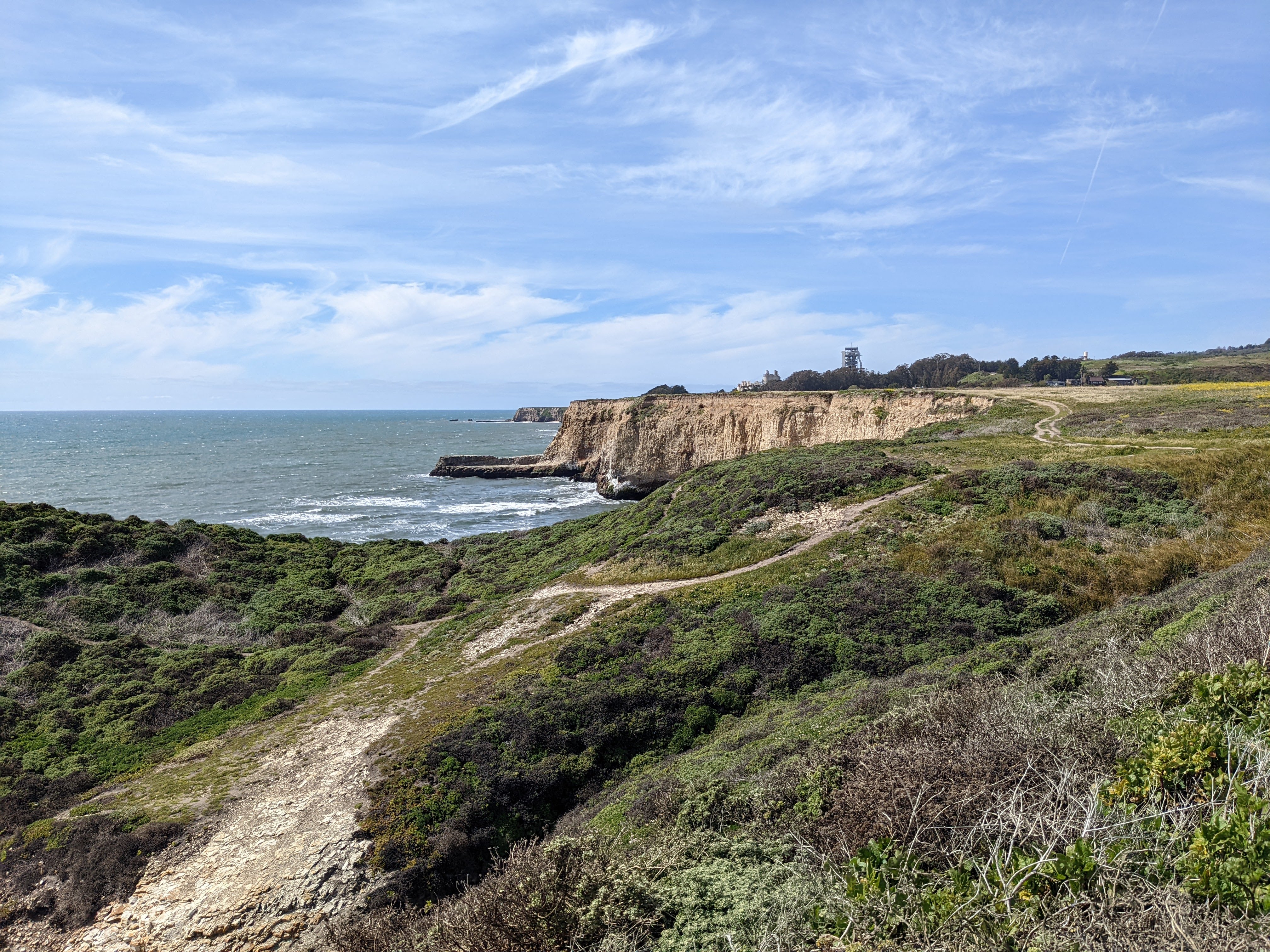
A scenery photo of the Pacific Ocean, Davenport, CA (right), clouds, and yellow mustard flower (right).
The photo was shot between Shark Fin Cove and Davenport Beach in Davenport, CA.

A scenery photo of wild flowers, clouds, hills, and a farm.
The photo was shot between Shark Fin Cove and Davenport Beach in Davenport, CA.

A scenery photo of yellow mustard flowers, Davenport, CA (left), hills, and clouds.
The photo was shot between Shark Fin Cove and Davenport Beach in Davenport, CA.

A photo of Sea Fig Flowers (Carpobrotus chilensis).
The photo was shot between Shark Fin Cove and Davenport Beach in Davenport, CA.

A scenery photo of yellow mustard flowers, Davenport Beach, Davenport Crack, Davenport, CA, hills, and clouds.
The photo was shot near Davenport Beach in Davenport, CA.

A scenery photo of yellow mustard flowers, clouds, hills, and a farm.
The photo was shot near Davenport Beach in Davenport, CA.

A photo of yellow mustard flowers, Milk Thistle (Silybum marianum), and clouds.
The photo was shot near Davenport Beach in Davenport, CA.

A scenery photo of yellow mustard flowers, Davenport Beach (right), the Pacific Ocean, and clouds.
The photo was shot near Davenport Beach in Davenport, CA.

A photo of Red Valerian Flowers (Centranthus ruber) and abandoned railroad tracks.
The photo was shot at the abandoned railroad tracks between Shark Fin Cove and Davenport Beach in Davenport, CA.

A photo of Red Valerian Flowers (Centranthus ruber) and abandoned railroad tracks.
The photo was shot at the abandoned railroad tracks between Shark Fin Cove and Davenport Beach in Davenport, CA.

A photo of Calla Lily Flowers (Zantedeschia aethiopica).
The photo was shot at the abandoned railroad tracks between Shark Fin Cove and Davenport Beach in Davenport, CA.

A photo of Forget-Me-Not Flowers (Myosotis latifolia).
The photo was shot at the abandoned railroad tracks between Shark Fin Cove and Davenport Beach in Davenport, CA.

A photo of wild blackberry flowers.
The photo was shot at the abandoned railroad tracks between Shark Fin Cove and Davenport Beach in Davenport, CA.

Our second stop was Scott Creek Beach in Davenport, CA.

A scenery photo of yellow mustard flowers, hills, and clouds.
The photo was shot near Scott Creek east of the State Route 1 bridge at Scott Creek Beach in Davenport, CA.

A scenery photo of Scott Creek, hills, and clouds.
The photo was shot east of the State Route 1 bridge at Scott Creek Beach in Davenport, CA.


A photo of a Sea Fig Flower (Carpobrotus chilensis).
The photo was shot at Scott Creek Beach in Davenport, CA.

Our third stop on this trip was Pigeon Point Light Station State Historic Park in Pescadero, CA. We saw a huge patch of yellow mustard flowers at the park near Pistachio Beach. I've been looking for a patch like this for a while. It was beautiful!

A scenery photo of yellow mustard flowers and clouds.
The photo was shot on Pigeon Point Road in Pigeon Point Light Station State Historic Park in Pescadero, CA.

A scenery photo of yellow mustard flowers and clouds.
The photo was shot on Pigeon Point Road in Pigeon Point Light Station State Historic Park in Pescadero, CA.

A scenery photo of Pistachio Beach, the Pacific Ocean, the sun, and clouds.
The photo was shot at Pistachio Beach in Pigeon Point Light Station State Historic Park in Pescadero, CA.

We finished off the day at Pescadero State Beach in Pescadero, CA. We went there to see sunset.

A sunset scenery photo of Pescadero State Beach, rocks, the Pacific Ocean, and clouds.
The photo was shot at Pescadero State Beach in Pescadero, CA.

A sunset scenery photo of Pescadero State Beach, the Pacific Ocean, mountains, and clouds.
The photo was shot at Pescadero State Beach in Pescadero, CA.

This is all the photos for today. I hope you have enjoyed viewing the photos! Please don't forget to share the blog post with your friends and family members! Also, if you want to get notifications when I post up more photos, "Like" us on Facebook or follow me on Instagram. These links can also be found on the top of the right sidebar.

Parts: Cellphone Photos | Olympus Photos

Wednesday, September 22, 2021

State Route 1 Day Trip - California (Cellphone Photos)

Yesterday, on 21 September, 2021, I took a day trip with my mom and traveled along California's State Route 1. I visited Scott Creek County Beach and Greyhound Rock County Park in Davenport, CA, and Gazos Creek State Beach and Pigeon Point Viewpoint in Pescadero, CA. Here are the cellphone photos I took on the trip. I also had some fun and had my mom helped me take some photos of me on this trip too. 

It was a really warm day by the ocean yesterday and not at all cloudy. I didn't even need to have my white cane with me (I'm partially blind with visual snow syndrome and migraines). My mom guiding me around when I had some trouble was enough for the entire day. I'm actually quite happy about that as having to use a white cane to get around do get a bit tiring and annoying sometimes. 

Scenery photo from Scott Creek Beach in Davenport, CA. In the distance is State Route 1.

Scenery photo from Scott Creek Beach in Davenport, CA.

Scenery photos of Scott Creek, Scott Creek Beach, and State Route 1 in Davenport, CA.

Scenery photo from Scott Creek Beach in Davenport, CA.

Scenery photo of Scott Creek Beach and State Route 1 in Davenport, CA.

Scenery photos from Scott Creek Beach in Davenport, CA.


Scenery photo from Greyhound Rock County Park in Davenport, CA.

My mom helped take a few photos of me at Greyhound Rock County Park in Davenport, CA.

Scenery photos from Greyhound Rock County Park in Davenport, CA.


Scenery photo from Greyhound Rock County Park in Davenport, CA.


Scenery photo of Gazaos Creek from Gazos Creek State Beach in Pescadero, CA.

Scenery photo of Gazaos Creek from Gazos Creek State Beach in Pescadero, CA. In the distance is Pigeon Point Lighthouse.

Scenery photo from Gazos Creek State Beach in Pescadero, CA. In the distance is Pigeon Point Lighthouse.

Scenery photo from Gazos Creek State Beach in Pescadero, CA.

California Brown Pelicans (Pelecanus occidentalis californicus)
Wildlife photo from Gazos Creek State Beach in Pescadero, CA.

My mom helped take a few photos of me at Gazos Creek State Beach in Pescadero, CA.

Dead seal or sea lion at Gazos Creek State Beach in Pescadero, CA. 😥


Sunset scenery photos from Pigeon Point Viewpoint in Pescadero, CA. In the photo is Pigeon Point Lighthouse.

My mom helped take a few photos of me at Pigeon Point Viewpoint in Pescadero, CA. In the distance is Pigeon Point Lighthouse.

This is all the photos for today. I hope you have enjoyed viewing the photos! Please don't forget to share the blog post with your friends and family members! Also, if you want to get notifications when I post up more photos, "Like" us on Facebook or follow me on Twitter and Instagram. These links can also be found on the top of the right sidebar.