Wednesday, July 22, 2015

Andrew Molera State Park - Big Sur, CA (Part 4)

On 4th of July I decided to take a trip to Monterey, Carmel, and Big Sur, CA. I went to places such as fisherman's Wharf, Garrapata State Park, Andrew Molera State Park, etc... I took many photos there are are here to share with you. About half of the photos were shot along or near SR-1. The photos will be split into several parts. I hope you enjoy viewing these photos!

Full Resolution Photos and Prints: If you want to see full resolution photos or buy prints of any of the photos you see, they are up on my portfolio for viewing. To view my best photos from Monterey, Big Sur area for 2014-2015, use this link. To see all of my photos from the Monterey, Big Sur area for 2014-2015, use this link.

Parts: 1 | 2 | 3 | 4 | 

Photos for today are from Andrew Molera State Park in Big Sur, CA. The photos from this park will be split into 2 parts. This is the second part.

After I was done at the beach, I took a hiking trail up to the highlands. Here is a scenery photo of the ocean from the highland area. 
Approximate GPS location (type into Google) according to the Canon GP-E2 GPS Receiver: 36 16 56 N 121 51 36 W   

  A black and white process of the photo above. 

Here is a high up scenery photo from the state park. The Big Sur River is to the left and the ocean is to the right. The scenery shots I took in the previous blog post was shot to that small patch of beach to the left of the photo (you could barely see it on the photo here). 
Approximate GPS location (type into Google) according to the Canon GP-E2 GPS Receiver: 36 16 53 N 121 51 37 W   

 A black and white process of the photo above.  

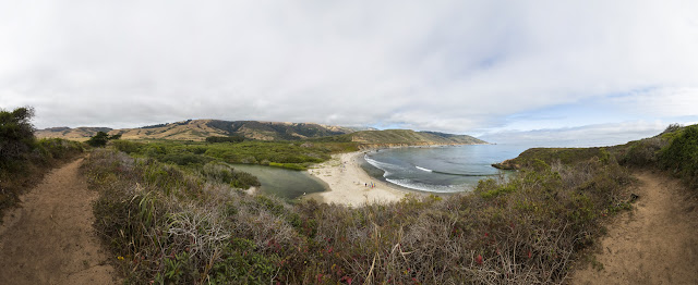
 A panorama shot of the view from the headlands. Big Sur River is to the left and the Pacific Ocean is to the right. Photo shot in the same spot as above. 


A scenery shot from the headlands of the Pacific Ocean.
Approximate GPS location (type into Google) according to the Canon GP-E2 GPS Receiver: 36 16 51 N 121 51 38 W   

A scenery shot from the headlands. This is a photo of the river mouth for the Big Sur River. You can see the place I was standing for the scenery shots in the previous blog post is left of the center a tiny bit. You can see it clearly on this photo. 
Approximate GPS location (type into Google) according to the Canon GP-E2 GPS Receiver: 36 16 49 N 121 51 35 W   

  A black and white process of the photo above. 


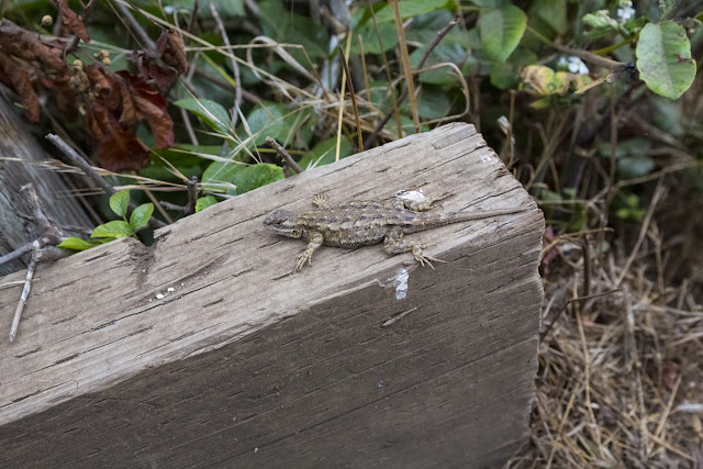
 On my hike back down from the headlands, I saw a Western Fence Lizard. 


Another few photos of the Western Fence Lizard. It wasn't scared of my camera and I at all.  

A scenery shot from near the walking trail on my walk back to the parking lot. 
Approximate GPS location (type into Google) according to the Canon GP-E2 GPS Receiver: 36 17 05 N 121 51 23 W   

 A black and white process of the photo above. 

This is all the photos for today and for this series! I hope you have enjoyed viewing the photos! Please don't forget to share the blog post with your friends and family members! Also, if you want to get notifications when I post up more photos, "Like" us on Facebook or follow me on Twitter and Instagram. These links can also be found on the top of the right sidebar.

Parts: 1 | 2 | 3 | 4 | 

Tuesday, July 21, 2015

Andrew Molera State Park - Big Sur, CA (Part 3)

On 4th of July I decided to take a trip to Monterey, Carmel, and Big Sur, CA. I went to places such as fisherman's Wharf, Garrapata State Park, Andrew Molera State Park, etc... I took many photos there are are here to share with you. About half of the photos were shot along or near SR-1. The photos will be split into several parts. I hope you enjoy viewing these photos!

Full Resolution Photos and Prints: If you want to see full resolution photos or buy prints of any of the photos you see, they are up on my portfolio for viewing. To view my best photos from Monterey, Big Sur area for 2014-2015, use this link. To see all of my photos from the Monterey, Big Sur area for 2014-2015, use this link.

Parts: 1 | 2 | 3 | 4

Photos for today are from Andrew Molera State Park in Big Sur, CA. The photos from this park will be split into 2 parts. This is the first part.

A photo of the forest and walking trail in the state park.  
Approximate GPS location (type into Google) according to the Canon GP-E2 GPS Receiver: 36 17 17 N 121 50 43 W


A photo of Big Sur River. 
Approximate GPS location (type into Google) according to the Canon GP-E2 GPS Receiver: 36 17 15 N 121 50 48 W 

Photo of the forest along the walking trail.  
Approximate GPS location (type into Google) according to the Canon GP-E2 GPS Receiver: 36 17 14 N 121 50 59 W


Another photo of the forest and the walking trail. 
Approximate GPS location (type into Google) according to the Canon GP-E2 GPS Receiver: 36 17 10 N 121 51 10 W 

Another scenery shot of the forest shot along the walking trail. Photo shot in the same spot as above. 

A black and white process of the photo above.  

According to Google Maps, this is called Cooper Cabin. I took a shot because I thought it made a great scene. 
Approximate GPS location (type into Google) according to the Canon GP-E2 GPS Receiver: 36 17 10 N 121 51 11 W 

 A black and white process of the photo above. 


A photo of Big Sur River shot along the walking trail. 
Approximate GPS location (type into Google) according to the Canon GP-E2 GPS Receiver: 36 16 58 N 121 51 33 W  

 A black and white process of the photo above.  

A guy sleeping on the riverbank of Big Sur River. I thought this made a really good composition so I took a shot. To the right is the Pacific Ocean. 
Approximate GPS location (type into Google) according to the Canon GP-E2 GPS Receiver: 36 16 54 N 121 51 35 W  

 A black and white process of the photo above. 


 Another photo of Big Sur River shot near the spot above. 

Another photo of Big Sur River shot near the spot above.  

 A black and white process of the photo above. 

This is all the photos for today! I hope you have enjoyed viewing the photos! Next time I will have the rest of the photos from Big Sur, CA shot in Andrew Molera State Park. Please don't forget to share the blog post with your friends and family members! Also, if you want to get notifications when I post up more photos, "Like" us on Facebook or follow me on Twitter and Instagram. These links can also be found on the top of the right sidebar.

Parts: 1 | 2 | 3 | 4

Sunday, July 19, 2015

Nitecore TM16 Flashlight Overview/Beam Shots (Video)


In this video I give you my first impressions, an overview, and beam shots of the Nitecore TM16 4000 Lumens Tiny Monster Flashlight. I will take you through the functions of the flashlight, the accessories that come with the flashlight, and some night time beam shots.

Warning: Hateful, rude, anti-LGBT comments will be deleted, and you may be banned from my channel.

Subscribe to my Youtube Channel here.

Saturday, July 18, 2015

Jarv NMotion Sport Bluetooth Earphones Review (Video)


I give you a a close look and review of the Jarv NMotion Sport Bluetooth Headphones. Use this device to listen to music and make calls hands-free with out wires tangling up! The headphones comes in black, green, pink, purple, and red colors. 

Warning: Hateful, rude, anti-LGBT comments will be deleted, and you may be banned from my channel.

Subscribe to my Youtube Channel here.

Thursday, July 16, 2015

SR-1 & Garrapata State Park - Carmel, CA (Part 2)

On 4th of July I decided to take a trip to Monterey, Carmel, and Big Sur, CA. I went to places such as fisherman's Wharf, Garrapata State Park, Andrew Molera State Park, etc... I took many photos there are are here to share with you. About half of the photos were shot along or near SR-1. The photos will be split into several parts. I hope you enjoy viewing these photos!

Full Resolution Photos and Prints: If you want to see full resolution photos or buy prints of any of the photos you see, they are up on my portfolio for viewing. To view my best photos from Monterey, Big Sur area for 2014-2015, use this link. To see all of my photos from the Monterey, Big Sur area for 2014-2015, use this link.

Parts: 1 | 2 | 3 | 4

Photos for today are scenery photos from along SR-1 and Garrapata State Park in Carmel, CA.

Scenery of the Pacific Ocean along SR-1 in Carmel, CA.
Approximate GPS location (type into Google) according to the Canon GP-E2 GPS Receiver: 36 28 09 N 121 55 56 W     


A black and white process of the photo above.  

Scenery of the Pacific Ocean near SR-1 in Carmel, CA. 
Approximate GPS location (type into Google) according to the Canon GP-E2 GPS Receiver: 36 28 08 N 121 55 57 W     

 A black and white process of the photo above. 


Another scenery shot of the Pacific Ocean near SR-1 in Carmel, CA. 
Approximate GPS location (type into Google) according to the Canon GP-E2 GPS Receiver: 36 28 11 N 121 56 02 W 

A black and white process of the photo above.  

A scenery shot from Garrapata State Park (right off of SR-1) in Carmel, CA. I decided to take a photo because I thought the clouds covering the hills looked nice. 
Approximate GPS location (type into Google) according to the Canon GP-E2 GPS Receiver: 36 25 11 N 121 54 50 W 

Another scenery shot from Garrapata State Park.
Approximate GPS location (type into Google) according to the Canon GP-E2 GPS Receiver: 36 25 10 N 121 54 51 W 

 A photo of Garrapata Beach in Garrapata State Park. 
Approximate GPS location (type into Google) according to the Canon GP-E2 GPS Receiver: 36 25 11 N 121 54 55 W 


Another scenery shot of Garrapata Beach from the same spot as above. I really liked how the clouds covered the tops of the hills.  

A black and white process of the photo above.  

Another scenery shot from Garrapata Beach. 
Approximate GPS location (type into Google) according to the Canon GP-E2 GPS Receiver: 36 25 15 N 121 54 54 W  

 A black and white process of the photo above. 


Two more scenery shots from Garrapata Beach shot at almost the same spot as above.  

A photo of the Bixby Creek Bridge in Monterey, CA. This is part of SR-1. 
Approximate GPS location (type into Google) according to the Canon GP-E2 GPS Receiver: 36 22 21 N 121 54 10 W 

This is all the photos for today! I hope you have enjoyed viewing the photos! Next time I will have photos from Big Sur, CA shot in Andrew Molera State Park. Please don't forget to share the blog post with your friends and family members! Also, if you want to get notifications when I post up more photos, "Like" us on Facebook or follow me on Twitter and Instagram. These links can also be found on the top of the right sidebar.

Parts: 1 | 2 | 3 | 4

Tuesday, July 14, 2015

Fisherman's Wharf - Monterey, CA (Part 1)

On 4th of July I decided to take a trip to Monterey, Carmel, and Big Sur, CA. I went to places such as fisherman's Wharf, Garrapata State Park, Andrew Molera State Park, etc... I took many photos there are are here to share with you. About half of the photos were shot along or near SR-1. The photos will be split into several parts. I hope you enjoy viewing these photos!

Full Resolution Photos and Prints: If you want to see full resolution photos or buy prints of any of the photos you see, they are up on my portfolio for viewing. To view my best photos from Monterey, Big Sur area for 2014-2015, use this link. To see all of my photos from the Monterey, Big Sur area for 2014-2015, use this link.

Parts: 1 | 2 | 3 | 4

Photos for today are from the Fisherman's Wharf area in Monterey, CA. I shot these photos after having a delicious sushi lunch there. I ate lunch at the same restaurant I did a few years back (Sapporo Sushi & Steakhouse). You can view those photos here. Sorry, no food photography this time though. Was too hungry. :D

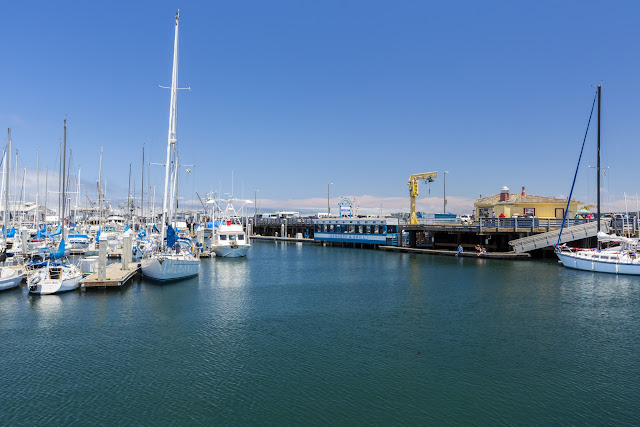
A photo of boats.
Approximate GPS location (type into Google) according to the Canon GP-E2 GPS Receiver: 36 36 08 N 121 53 27 W     

A black and white process of the photo above. 

A photo of boats and the pier. 
Approximate GPS location (type into Google) according to the Canon GP-E2 GPS Receiver: 36 36 07 N 121 53 26 W  

 A black and white process of the photo above.


Another photo of boats. 
Approximate GPS location (type into Google) according to the Canon GP-E2 GPS Receiver: 36 36 09 N 121 53 29 W  

A black and white process of the photo above. 

A photo of a boat ramp with lots of boats in the background. 
Approximate GPS location (type into Google) according to the Canon GP-E2 GPS Receiver: 36 36 08 N 121 53 28 W  

A black and white process of the photo above.

This is all the photos for today! I hope you have enjoyed viewing the photos! Next time I will have photos from Carmel, CA shot along SR-1 and from Garrapata State Park. Please don't forget to share the blog post with your friends and family members! Also, if you want to get notifications when I post up more photos, "Like" us on Facebook or follow me on Twitter and Instagram. These links can also be found on the top of the right sidebar.

Parts: 1 | 2 | 3 | 4