Showing posts with label deer. Show all posts

Tuesday, November 11, 2025

Coloma & Placerville (Part 3) - California

On the 31st October 2025, my parents and I took a trip to Sacramento, CA and dropped by Coloma, CA and Placerville, CA. We went to go see autumn foliage, but it was a bit early, at least for Sacramento. It was still a nice trip. I took photos with my phone, and the photos are split into 3 posts. I hope you enjoy viewing my photos!

Parts: 1 | 2 | 3

This blog post has photos of sunset from Marshall Gold Discovery State Historic Park in Coloma, CA, and night time Halloween celebrations at Downtown Placerville, CA.

After we finished up in Sacramento, CA, we made the drive over to The Mother Lode. We arrived at Marshall Gold Discovery State Historic Park in Coloma, CA at around sunset. The park was closed, but we parked on the side of State Route 49 and roamed the grounds for a short period of time. It was a very beautiful area, especially at sunset.

Marshall Gold Discovery State Park is the location of where gold was first discovered in California. The discovery was made by James W. Marshall in 1848, and it kick started the California Gold Rush.

A sunset scenery photo of Canada Geese (Branta canadensis), deer, autumn foliage, historic buildings, hills, and trees. The photo was shot at Marshall Gold Discovery State Historic Park in Coloma, CA.

A sunset scenery photo of Canada Geese (Branta canadensis), deer, autumn foliage, moon (top left), historic buildings, and trees. The photo was shot at Marshall Gold Discovery State Historic Park in Coloma, CA.

A sunset scenery photo of the Coloma, CA Post Office, autumn foliage, clouds, and hills. The photo was shot at Marshall Gold Discovery State Historic Park in Coloma, CA.

A sunset scenery photo of autumn foliage, clouds, State Route 49, hills, trees, and historic buildings. The photo was shot at Marshall Gold Discovery State Historic Park in Coloma, CA.

A sunset scenery photo of autumn foliage, clouds, State Route 49 (right), hills, trees, and historic buildings. The photo was shot at Marshall Gold Discovery State Historic Park in Coloma, CA.

A sunset scenery photo of autumn foliage, clouds, State Route 49, hills, trees, and historic buildings. The photo was shot at Marshall Gold Discovery State Historic Park in Coloma, CA.

A sunset scenery photo of clouds, autumn foliage, hills, historic buildings, and trees. The photo was shot at Marshall Gold Discovery State Historic Park in Coloma, CA.

A sunset scenery photo of Gold Trail Grange, clouds, autumn foliage, State Route 49, hills, and trees. The photo was shot at Marshall Gold Discovery State Historic Park in Coloma, CA.

A sunset scenery photo of autumn foliage, South Fork American River, clouds, Coloma Resort (left), hills, and moon. The photo was shot on Coloma Bridge at Marshall Gold Discovery State Historic Park in Coloma, CA.

A sunset scenery photo of autumn foliage, South Fork American River (left), and hills. The photo was shot on Coloma Bridge at Marshall Gold Discovery State Historic Park in Coloma, CA.

A sunset scenery photo of autumn foliage, South Fork American River, clouds, hills, and power lines. The photo was shot on Coloma Bridge at Marshall Gold Discovery State Historic Park in Coloma, CA.

A sunset scenery photo of clouds, autumn foliage, State Route 49, hills, historic buildings, and trees. The photo was shot at Marshall Gold Discovery State Historic Park in Coloma, CA.

After Coloma, CA, we decided to drop by Downtown Placerville, CA to see if there is any autumn foliage we can see at night. I wanted to scout out the area for our next trip. This was when I remembered it was October 31st and it was Halloween. We happened to have come upon the tail end of the Halloween celebration in Downtown Placerville. 

A scenery photo of the Halloween Celebration at night in Downtown Placerville, CA. In the photo are historic buildings.

My mom helped take a photo of me next to the giant inflatable pumpkin in they had up for the Halloween celebration. In the photo are historic buildings. The photo was shot at night in Downtown Placerville, CA.

My mom helped take a photo of me next to the giant inflatable pumpkin in they had up for the Halloween celebration. In the photo are historic buildings. The photo was shot at night in Downtown Placerville, CA.

My mom helped take a photo of me next to the giant inflatable pumpkin in they had up for the Halloween celebration. In the photo are historic buildings. The photo was shot at night in Downtown Placerville, CA.

This is all the photos for today and from this trip. I hope you have enjoyed viewing the photos! Please don't forget to share the blog post with your friends and family members! Also, if you want to get notifications when I post up more photos, "Like" us on Facebook or follow me on Instagram. These links can also be found on the top of the right sidebar.

Parts: 1 | 2 | 3

Friday, May 12, 2023

Morgan Territory & Los Vaqueros Reservoir (Cellphone Photos)

Yesterday, on 11 May 2023, my mom and I took short hike through Morgan Territory Regional Preserve in Livermore, CA and walked a short distance into Los Vaqueros Watershed in Contra Costa County, CA. I took photos with my cellphone. I hope you enjoy viewing my photos!

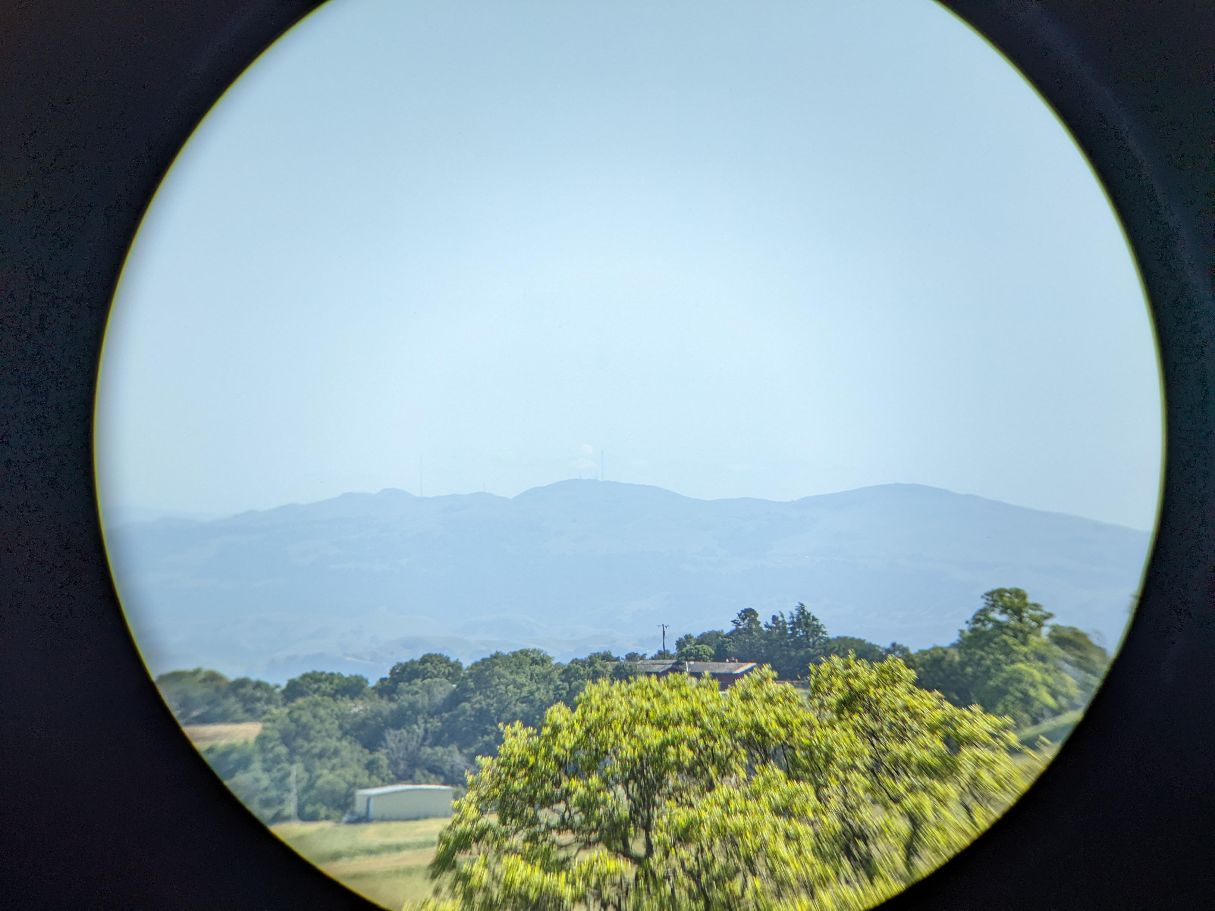
One of the main purposes of my trip today was to test my new Vanguard BA-195 Binocular Tripod Adapter (Product Link - Affiliate Link). The binoculars I used was the Bushnell Engage X 10x42mm Binoculars (Product Link - Affiliate Link). The Vanguard binocular tripod adapter performed very well and the set up didn't wobble at all. The most issue I had was with my binoculars rotating a tiny bit on the mount, but you really can't blame it as it is mounted by a screw. This is way better than the first binocular tripod adapter I got (which I had returned), the Staoptics Binocular Tripod Adapter with Quick Release (Product Link - Affiliate Link). Not only did the Staoptics adapter have an extra long screw which was too long for my Bushnell binoculars, my binoculars just kept rotating and wobbling on the mount. I used the Staoptics one for a little over a week before I returned it. If you're looking for a quality binocular tripod adapter, go with the Vanguard BA-195 Binocular Tripod Adapter (Product Link - Affiliate Link). I used Vanguard tripods for many years for my photography, and they are a brand I trust. If I had known Vanguard makes binocular tripod mounts, I would have went directly with theirs instead of messing around with other brands.

A photo shot through my binoculars.
A photo of Mt. Allison (center), Mission Peak (right), trees, a house, and a storage shed. The photo was shot on Whipsnake Trail in Morgan Territory Regional Preserve in Livermore, CA.
Binoculars Used: Bushnell Engage X 10x42mm Binoculars (Product Link - Affiliate Link)

A photo shot through my binoculars.
A photo of Sunol Peak (center), a green hill, and trees. The photo was shot on Whipsnake Loop Trail in Los Vaqueros Watershed in Contra Costa County, CA.
Binoculars Used: Bushnell Engage X 10x42mm Binoculars (Product Link - Affiliate Link)

A photo shot through my binoculars.
A photo of Stockton, CA and farms. The photo was shot near Whipsnake Loop Trail in Los Vaqueros Watershed in Contra Costa County, CA.
Binoculars Used: Bushnell Engage X 10x42mm Binoculars (Product Link - Affiliate Link)

A photo shot through my binoculars.
A photo of Stockton, CA and farms. The photo was shot near Whipsnake Loop Trail in Los Vaqueros Watershed in Contra Costa County, CA.
Binoculars Used: Bushnell Engage X 10x42mm Binoculars (Product Link - Affiliate Link)

A scenery photo of Los Vaqueros Reservoir (foreground), Clifton Court Forebay (in the distance on the left), windmills & Tracy, CA (right), and trees. The photo was shot near Whipsnake Loop Trail in Los Vaqueros Watershed in Contra Costa County, CA.

A photo shot through my binoculars.
A photo of two black tailed deer, green hill, and trees. The photo was shot near Whipsnake Trail in Morgan Territory Regional Preserve in Livermore, CA.
Binoculars Used: Bushnell Engage X 10x42mm Binoculars (Product Link - Affiliate Link)

A photo shot through my binoculars.
A photo of a black tailed deer, green hill, and trees. The photo was shot near Whipsnake Trail in Morgan Territory Regional Preserve in Livermore, CA.
Binoculars Used: Bushnell Engage X 10x42mm Binoculars (Product Link - Affiliate Link)

A photo shot through my binoculars.
A photo of two black tailed deer, green hill, and trees. The photo was shot near Whipsnake Trail in Morgan Territory Regional Preserve in Livermore, CA.
Binoculars Used: Bushnell Engage X 10x42mm Binoculars (Product Link - Affiliate Link)

A photo shot through my binoculars.
A photo of two black tailed deer, green hill, and trees. The photo was shot near Whipsnake Trail in Morgan Territory Regional Preserve in Livermore, CA.
Binoculars Used: Bushnell Engage X 10x42mm Binoculars (Product Link - Affiliate Link)

A photo shot through my binoculars.
A photo of a squirrel and grass. The photo was shot near Whipsnake Trail in Morgan Territory Regional Preserve in Livermore, CA.
Binoculars Used: Bushnell Engage X 10x42mm Binoculars (Product Link - Affiliate Link)

A photo shot through my binoculars.
A photo of a squirrel and grass. The photo was shot near Whipsnake Trail in Morgan Territory Regional Preserve in Livermore, CA.
Binoculars Used: Bushnell Engage X 10x42mm Binoculars (Product Link - Affiliate Link)

This is all the photos for today. I hope you have enjoyed viewing the photos! Please don't forget to share the blog post with your friends and family members! Also, if you want to get notifications when I post up more photos, "Like" us on Facebook or follow me on Instagram. These links can also be found on the top of the right sidebar.

Monday, April 24, 2023

Deer in Sunol Regional Wilderness (Cellphone Photos) - Sunol, CA

Today, on 24 April 2023, my mom and I went walking and hiking in Sunol Regional Wilderness in Sunol, CA. On the way out of the park, we saw a few black tailed deer. I quickly snapped a few photos with my cellphone. I hope you enjoy viewing the photos.

All the photos in this blog post were shot during sunset on Geary Road.

A photo of two black tailed deer, wild flowers, and forest.

A photo of a black tailed deer, wild flowers, and forest.

A photo of a black tailed deer running, wild flowers, and forest.

A photo of a black tailed deer running, wild flowers, and forest.

This is all the photos for today. I hope you have enjoyed viewing the photos! Please don't forget to share the blog post with your friends and family members! Also, if you want to get notifications when I post up more photos, "Like" us on Facebook or follow me on Instagram. These links can also be found on the top of the right sidebar.

Tuesday, March 14, 2023

Yellow Mustard Flowers & Deer (Cellphone Photos) - Contra Costa County, CA

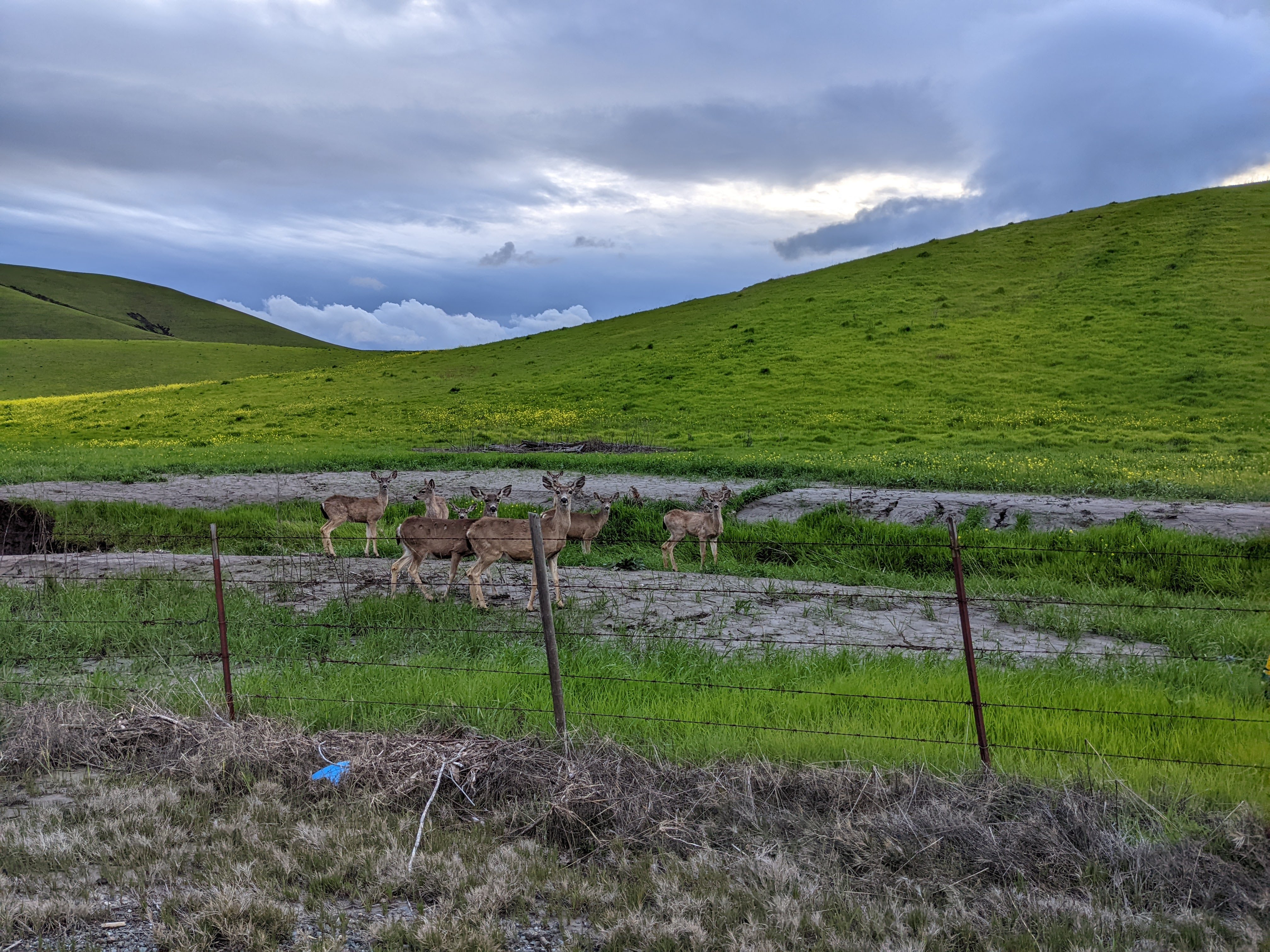
Yesterday, on 13 March 2023, my mom and I drove along Highland Road in unincorporated Pleasanton, CA and Livermore, CA (Contra Costa County, CA). We saw a lot of yellow mustard flowers and a few deer. I took photos with my cellphones. I hope you enjoy viewing the photos.

A scenery photo of yellow mustard flowers, green hills, clouds, farm, a barbed wire fence, high voltage power lines, my shadow, and Highland Road. The photo was shot in unincorporated Pleasanton, CA.

A scenery photo of yellow mustard flowers, green hills, clouds, a barbed wire fence, and my shadow. The photo was shot on the side of Highland Road in unincorporated Pleasanton, CA.

A scenery photo of yellow mustard flowers, green hills, and clouds. The photo was shot on the side of Highland Road in unincorporated Pleasanton, CA.

A scenery photo of yellow mustard flowers, green hills, and clouds. The photo was shot on the side of Highland Road in unincorporated Pleasanton, CA.

A scenery photo of deer, yellow mustard flowers, green hills, clouds, and a barbed wire fence. The photo was shot on the side of Highland Road in unincorporated Livermore, CA.

A scenery photo of deer, yellow mustard flowers, green hills, clouds, and a barbed wire fence. The photo was shot on the side of Highland Road in unincorporated Livermore, CA.

A scenery photo of deer, yellow mustard flowers, green hills, clouds, and a barbed wire fence. The photo was shot on the side of Highland Road in unincorporated Livermore, CA.

This is all the photos for today. I hope you have enjoyed viewing the photos! Please don't forget to share the blog post with your friends and family members! Also, if you want to get notifications when I post up more photos, "Like" us on Facebook or follow me on Instagram. These links can also be found on the top of the right sidebar.

Saturday, April 7, 2018

January Cellphone Photos

After CES Las Vegas 2018 in January (photos here), I vacationed a bit afterwards. I visited places such as Red Rock Canyon National Conservation Area in Las Vegas, NV, Lake Mead National Recreation Area and Hoover Dam in Nevada/Arizona, Death Valley National Park, Alabama Hills and more. Here are the cellphone photos (except the CES ones) that I shot in January. My DSLR photos will be posted as I publish them. The post is quite long so it might take a while to load on slow connections.

DSLR Photos:
  • Red Rock Canyon NCA - Las Vegas, NV: 1 | 2 |
  • Lake Mead NRA/Hoover Dam - NV/AZ: 1 | 2 | 3 |
  • Death Valley National Park - CA/NV: 1 | 2 | 3 | 4 | 5 | 6 | 7 | 8 | 9 | 10 | 11 | 
  • Alabama Hills/Inyo National Forest: 1 | 2 | Inyo National Forest | 
Photos from Red Rock Canyon National Conservation Area in Las Vegas, NV shot on January 13th. The park was pretty crowded.

Shot some photos out of the car while waiting in traffic.

Photos from inside the visitor center.

Panorama from the visitor center.

Scenery from Red Rock Canyon NCA.

Photos from Lake Mead National Recreation Area in Nevada shot on January 14th.

Panorama from Lake Mead NRA on the Nevada side.

Scenery from Lake Mead NRA on the Nevada side.

Scenery of Lake Mead from Lake Mead NRA on the Nevada side.

Photo of Mike O'Callaghan - Pat Tillman Memorial Bridge shot from parking complex at Hoover Dam Mercantile on the Nevada side. Photo from January 14th.

Photo of Hoover Dam shot on the Nevada side.

Photo from Hoover Damn shot at the state line of Nevada and Arizona. In the background is Lake Mead.

Photo of Mike O'Callaghan - Pat Tillman Memorial Bridge shot from parking complex at Hoover Dam Mercantile on the Nevada side. Photo from January 14th.

Photo of Area 51 Alien Center in Amargosa Valley, NV shot on January 15th.

Photo of Mt. Whitney and Eastern Sierras shot from Best Western Plus Frontier Motel in Lone Pine, CA on January 16th.

Photo of Mt. Whitney and Eastern Sierras shot from Best Western Plus Frontier Motel in Lone Pine, CA on January 16th.

Photos from Best Western Plus Frontier Motel in Lone Pine, CA on January 16th.

Photo of Eastern Sierras shot from Best Western Plus Frontier Motel in Lone Pine, CA on January 16th.

Photo of Mt. Whitney and Eastern Sierras shot from Best Western Plus Frontier Motel in Lone Pine, CA on January 16th.

Panorama of Eastern Sierras shot on State Route 136 in Inyo County, CA. Photo from January 16th.

Panorama from Father Crowley Point in Death Valley National Park in California. Photo from January 16th.

Scenery from Father Crowley Point in Death Valley National Park in California. Photo from January 16th.

Scenery from Alabama Hills in Lone Pine, CA shot on January 17th.

Scenery of Movie Road from Alabama Hills in Lone Pine, CA shot on January 17th.

Mojave Fishhook Cactus (Sclerocactus polyancistrus) from Mobius Arch Loop Trail in Alabama Hills in Lone Pine, CA.

Scenery of Mt. Whitney and Eastern Sierras from Mobius Arch Loop Trail in Alabama Hills in Lone Pine, CA.

Scenery from Mobius Arch Loop Trail in Alabama Hills in Lone Pine, CA.

Scenery of Mt. Whitney and Eastern Sierras shot from Whitney Portal Road in Inyo National Forest in California.

Panorama shot from Whitney Portal Road in Inyo National Forest in California.

Panorama of Mt. Whitney, Eastern Sierras, and Whitney Portal Road in Inyo National Forest in California.


Panorama shot from Whitney Portal Road in Inyo National Forest in California.
Warning: I did go past a road closure to get this photo. I do not support or recommend going past road closures. You do so at your own risk. When I drove up the road, I saw sand and rocks on the ground from slides. This can affect tire traction on cars, possibly trap you, or worse! The roads are closed for a reason. I took the risk going up there for photography (and I saw a couple other cars do the same). I'm not here to recommend doing this. Doing so is extremely dangerous and may lead to loss of life. Don't say you didn't get warned.

Photo of deer shot near Whitney Portal Road in Inyo National Forest in California.

Photo of deer shot near Whitney Portal Road in Inyo National Forest in California.

This is all the photos for today. I hope you have enjoyed the photos! Please don't forget to share the blog post with your friends and family members! Also, if you want to get notifications when I post up more photos, "Like" us on Facebook or follow me on Twitter and Instagram. These links can also be found on the top of the right sidebar.