Showing posts with label jenner. Show all posts

Sunday, February 25, 2024

Sonoma Coast State Park (Part 2) - Sonoma County, CA

On 28 January 2024, my parents and I took a trip to Sonoma Coast State Park in Sonoma County, CA. I took a bunch of photos at the park and on the drive there with both my Olympus mirrorless camera and my cellphone. The photos are split into several blog posts. I hope you enjoy viewing the photos.

High Resolution Photos: If you want to see high resolution photos of any of the photos you see here, use the following links. If you wish to purchase prints of any of the photos, please contact me here. To see all of my photos from this trip, use this link.

Parts: 1 | 2 | Cellphone Photos

The photos for today are from Bodega Head, Duncan's Landing, and Pomo Canyon Trail in Sonoma Coast State Park in Sonoma County, CA.

Our first stop in Sonoma Coast State Park was Bodega Head.

An abstract long exposure photo of waves over rocks, and Pacific Ocean. The photo was shot at Bodega Head in Sonoma Coast State Park.
The long exposure was achieved using an ND filter.
Approximate GPS location (type into Google): 38° 18' 11" N 123° 03' 51" W

A black and white process of the photo above.

A long exposure photo of Tomales Point, Point Reyes National Seashore, Tomales Bay (left), Pacific Ocean (right), and clouds. The photo was shot at Bodega Head in Sonoma Coast State Park.
The long exposure was achieved using an ND filter.
Approximate GPS location (type into Google): 38° 18' 00" N 123° 03' 40" W

Our next stop was Duncan's Landing in Sonoma Coast State Park.

An abstract long exposure photo of Duncan's Cove, rocks, mountains, and clouds. The photo was shot at Duncan's Landing in Sonoma Coast State Park.
The long exposure was achieved using an ND filter.
Approximate GPS location (type into Google): 38° 23' 42" N 123° 05' 39" W

A black and white process of the photo above.

A long exposure photo of Hogback (rocks), Pacific Ocean, and clouds. The photo was shot at Duncan's Landing in Sonoma Coast State Park.
The long exposure was achieved using an ND filter.
Approximate GPS location (type into Google): 38° 23' 41" N 123° 05' 46" W

A long exposure photo of Hogback (foreground rocks), Pacific Ocean, and clouds. The photo was shot at Duncan's Landing in Sonoma Coast State Park.
The long exposure was achieved using an ND filter.
The photo was shot at the same spot as above.

A long exposure photo of Duncan's Cove, rocks, mountains, and clouds. The photo was shot at Duncan's Landing in Sonoma Coast State Park.
The long exposure was achieved using an ND filter.
Approximate GPS location (type into Google): 38° 23' 36" N 123° 05' 40" W

A long exposure photo of Duncan's Cove, rocks, mountains, and clouds. The photo was shot at Duncan's Landing in Sonoma Coast State Park.
The long exposure was achieved using an ND filter.
The photo was shot at the same spot as above.

A black and white process of the photo above.

Next we went for a hike on Pomo Canyon Trail in Sonoma Coast State Park. Unfortunately the trail conditions were terrible due to the recent rainstorms so we didn't get very far. I was hoping to get star trail photos over Russian River, but it didn't end up happening. 

A scenery photo of Russian River, State Route 1, State Route 116 (right), Penny Island, Jenner, Pacific Ocean (in the distance), and clouds. The photo was shot on Pomo Canyon Trail in Sonoma Coast State Park.
Approximate GPS location (type into Google): 38° 25' 42" N 123° 05' 37" W

A black and white process of the photo above.

A scenery photo of rocks, bushes, and clouds. The photo was shot on Pomo Canyon Trail in Sonoma Coast State Park.
Approximate GPS location (type into Google): 38° 25' 36" N 123° 05' 42" W

A scenery photo of sunset over the Pacific Ocean with clouds in the sky. The photo was shot on Pomo Canyon Trail in Sonoma Coast State Park.
Approximate GPS location (type into Google): 38° 25' 26" N 123° 05' 58" W

A scenery photo of sunset over the Pacific Ocean with clouds in the sky. The photo was shot on Pomo Canyon Trail in Sonoma Coast State Park.
The photo was shot at the same spot as above.

A photo of sunset (orange) coloured clouds in the sky. The photo was shot on Pomo Canyon Trail in Sonoma Coast State Park.
The photo was shot at the same spot as above.

A photo of sunset (orange) coloured clouds in the sky. The photo was shot on Pomo Canyon Trail in Sonoma Coast State Park.
The photo was shot at the same spot as above.

A photo of sunset (orange) coloured clouds in the sky. The photo was shot on Pomo Canyon Trail in Sonoma Coast State Park.
The photo was shot at the same spot as above.

A sunset scenery photo of the Pacific Ocean, hills, and clouds. The photo was shot on Pomo Canyon Trail in Sonoma Coast State Park.
Approximate GPS location (type into Google): 38° 25' 19" N 123° 06' 04" W

A black and white process of the photo above.

A sunset scenery photo of the Pacific Ocean, hills, and clouds. The photo was shot on Pomo Canyon Trail in Sonoma Coast State Park.
The photo was shot near the same spot as above.

A black and white process of the photo above.

This is all the photos for today. I hope you have enjoyed viewing the photos! Please don't forget to share the blog post with your friends and family members! Also, if you want to get notifications when I post up more photos, "Like" us on Facebook or follow me on Instagram. These links can also be found on the top of the right sidebar.

Parts: 1 | 2 | Cellphone Photos

Saturday, May 27, 2023

Sonoma Coast SP, Jenner, Duncans Mills (Part 3) - Sonoma County, CA

On 7 May 2023, my mom and I took a day trip to Sonoma Coast State Park in Sonoma County, CA. We went to the various beaches in the state park, took a hike along Red Hill Trail, and visited Bodega Bay, Jenner, and Duncans Mills, CA. We saw the Russian River, harbor seals (Phoca vitulina), and lots of wild flowers. I took photos with my cellphone and mirrorless camera. The photos are split into 4 blog posts (I took most of the photos on my mirrorless camera). I hope you enjoy viewing my photos!

High Resolution Photos: If you want to see high resolution photos of any of the photos you see here, use the following links. If you wish to purchase prints of any of the photos, please contact me here. To see my best Sonoma Coast State Park photos and photos from surrounding areas, use this link. To see my best sunset and night photography photos from 2019 to 2023, use this link. To see all of my photos from this trip from Sonoma Coast State Park, use this link. To see all of my photos from Sonoma County, CA, use this link.

Parts: 1 | 2 | 3 | Cellphone Photos

This is part 3 of the photos shot on my Olympus mirrorless camera. The photos in this blog post were shot at Goat Rock Beach in Sonoma Coast State Park, at Russian River Vista Point in Jenner, CA, along State Route 1, and in Duncans Mills, CA.

After my mom and I finished the hike at Red Hill Trail, we went to Goat Rock Beach.

A scenery photo of Arched Rock, the Pacific Ocean, and rocks. The photo was shot at Goat Rock Beach Parking Lot in Sonoma Coast State Park.
Approximate GPS location (type into Google): 38° 26' 27" N 123° 07' 33" W

A scenery photo of Blind Beach (left), Arched Rock (right), the Pacific Ocean, rocks, and cliffs. The photo was shot at Goat Rock Beach Parking Lot in Sonoma Coast State Park.
Photo shot at the same spot as above.

A scenery photo of Russian River, Jenner, houses, clouds, and green hills. The photo was shot at Goat Rock Beach in Sonoma Coast State Park.
The flowers in the photo are Cow Parsnip (Heracleum maximum) and Pride of Madeira Flowers (Echium candicans).
Approximate GPS location (type into Google): 38° 26' 57" N 123° 07' 36" W

A scenery photo of Russian River, Jenner, houses, clouds, and green hills. The photo was shot at Goat Rock Beach in Sonoma Coast State Park.
The flowers in the photo are Calla Lily (Zantedeschia aethiopica) and Pride of Madeira Flowers (Echium candicans).
Photo shot at the same spot as above.

A scenery photo of Harbour Seals (Phoca vitulina), Russian River, State Route 1 (top), and clouds. The photo was shot at Goat Rock Beach in Sonoma Coast State Park.
The flowers in the photo are Cow Parsnip (Heracleum maximum) and Pride of Madeira Flowers (Echium candicans).
Approximate GPS location (type into Google): 38° 27' 01" N 123° 07' 44" W

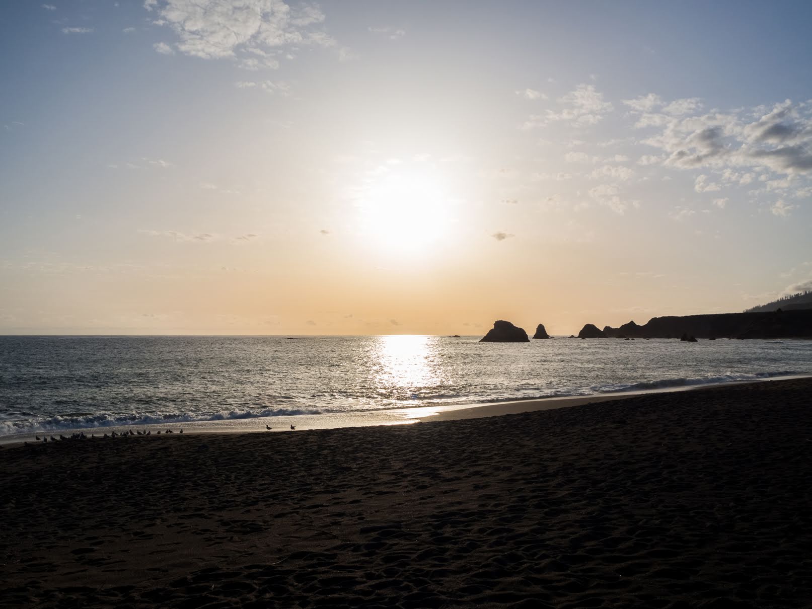
A scenery photo of Goat Rock Beach, seagulls & driftwood (left), Goat Rock (right), rocks, and the Pacific Ocean. The photo was shot in Sonoma Coast State Park.
Approximate GPS location (type into Google): 38° 26' 58" N 123° 07' 42" W

A scenery photo of Goat Rock Beach, seagulls (left), rocks, clouds, and the Pacific Ocean. The photo was shot in Sonoma Coast State Park.
Approximate GPS location (type into Google): 38° 26' 54" N 123° 07' 39" W

A scenery photo of Goat Rock Beach, State Route 1, Russian River (right), Jenner (right), the Pacific Ocean, mountains, rocks, cliffs, and clouds. The photo was shot on the side of Goat Rock Road in Sonoma Coast State Park.
Approximate GPS location (type into Google): 38° 26' 31" N 123° 07' 29" W

A scenery photo of Blind Beach (left), Arched Rock (right), the Pacific Ocean, rocks, and cliffs. The photo was shot on the side of Goat Rock Road in Sonoma Coast State Park.
Photo shot at the same spot as above.

A scenery photo of Arched Rock, the Pacific Ocean, and rocks. The photo was shot on the side of Goat Rock Road in Sonoma Coast State Park.
Photo shot at the same spot as above.

A scenery photo of Arched Rock, the Pacific Ocean, clouds, and rocks. The photo was shot on the side of Goat Rock Road in Sonoma Coast State Park.
The flowers in this photo are Cow Parsnip (Heracleum maximum).
Approximate GPS location (type into Google): 38° 26' 17" N 123° 07' 16" W

It was getting close to sunset once my mom and I finished up at Goat Rock State Beach. We hit up a few more spots along State Route 1 for sunset.

A sunset scenery photo of Russian River Bridge (State Route 1), Russian River, RV park, houses, trees, cows, clouds, and mountains. The photo was shot at Russian River Vista Point on the side of State Route 1 in Jenner, CA.
The flowers in the photo are Cow Parsnip (Heracleum maximum).
Approximate GPS location (type into Google): 38° 25' 55" N 123° 06' 07" W

A black and white process of the photo above.

A scenery photo of sunset over the Pacific Ocean, with clouds. The photo was shot on the side of State Route 1 in Sonoma Coast State Park.
The flowers in the photo are Cow Parsnip (Heracleum maximum) and Yellow Mustard Flowers.
Approximate GPS location (type into Google): 38° 27' 30" N 123° 08' 30" W

A scenery photo of sunset over the Pacific Ocean, with clouds. The photo was shot on the side of State Route 1 in Sonoma Coast State Park.
The flowers in the photo are Cow Parsnip (Heracleum maximum).
Photo shot at the same spot as above.

A scenery photo of sunset over the Pacific Ocean, with clouds. The photo was shot on the side of State Route 1 in Sonoma Coast State Park.
The flowers in the photo are Cow Parsnip (Heracleum maximum).
Photo shot at the same spot as above.

A scenery photo of sunset over the Pacific Ocean, with clouds. The photo was shot on the side of State Route 1 in Sonoma Coast State Park.
The flowers in the photo are Cow Parsnip (Heracleum maximum).
Photo shot at the same spot as above.

After sunset, my mom and I started our trip back home. On our trip back home, we took State Route 116 and passed by Duncans Mills, CA. It was dusk by the time we got there.

A dusk long exposure scenery photo of the Historic Duncans Mills Railroad Station in Duncans Mills, CA. Also in the photo are a heavily forested hill, clouds, and a State Parks vehicle (right).
The trees in the photo are Coast Redwoods (Sequoia sempervirens).
Approximate GPS location (type into Google): 38° 27' 12" N 123° 03' 13" W

A black and white process of the photo above.

A dusk long exposure scenery photo of the Historic Duncans Mills Railroad Station in Duncans Mills, CA. Also in the photo are parking spaces and clouds.
The trees in the photo are Coast Redwoods (Sequoia sempervirens).
Approximate GPS location (type into Google): 38° 27' 12" N 123° 03' 12" W

This is all the photos for today. I hope you have enjoyed viewing the photos! Please don't forget to share the blog post with your friends and family members! Also, if you want to get notifications when I post up more photos, "Like" us on Facebook or follow me on Instagram. These links can also be found on the top of the right sidebar.

Parts: 1 | 2 | 3 | Cellphone Photos

Sunday, May 21, 2023

Red Hill Trail (Part 2) - Sonoma Coast State Park

On 7 May 2023, my mom and I took a day trip to Sonoma Coast State Park in Sonoma County, CA. We went to the various beaches in the state park, took a hike along Red Hill Trail, and visited Bodega Bay, Jenner, and Duncans Mills, CA. We saw the Russian River, harbor seals (Phoca vitulina), and lots of wild flowers. I took photos with my cellphone and mirrorless camera. The photos are split into 4 blog posts (I took most of the photos on my mirrorless camera). I hope you enjoy viewing my photos!

High Resolution Photos: If you want to see high resolution photos of any of the photos you see here, use the following links. If you wish to purchase prints of any of the photos, please contact me here. To see all of my photos from this trip, use this link.

Parts: 1 | 2 | 3Cellphone Photos

This is part 2 of the photos shot on my Olympus mirrorless camera. After Duncan's Landing, my mom and I took a hike on Red Hill Trail. The photos in this blog post were shot on Red Hill Trail in Sonoma Coast State Park. The main subjects of the photos are of the Russian River and Jenner.

A scenery photo of forest, mountains, and clouds. The photo was shot on Red Hill Trail.
The flowers in the photo are Cow Parsnip (Heracleum maximum).
Approximate GPS location (type into Google): 38° 25' 26" N 123° 05' 47" W

A scenery photo of Russian River, Jenner, Penny Island (center), State Route 1, State Route 116 (right), the Pacific Ocean (left), forest, mountains, and clouds. The photo was shot on Red Hill Trail.
The trees in the photo are Coast Redwoods (Sequoia sempervirens).
The flowers in the photo are Cow Parsnip (Heracleum maximum) and Douglas Iris (Iris douglasiana).
Approximate GPS location (type into Google): 38° 25' 32" N 123° 05' 40" W

A scenery photo of Russian River, Jenner, Penny Island (center), State Route 1, State Route 116 (right), the Pacific Ocean (left), forest, mountains, and clouds. The photo was shot on Red Hill Trail.
The trees in the photo are Coast Redwoods (Sequoia sempervirens).
Photo shot at the same spot as above.

A scenery photo of Russian River, Jenner, Penny Island (center), State Route 1, State Route 116 (right), the Pacific Ocean (left), forest, mountains, and clouds. The photo was shot on Red Hill Trail.
The trees in the photo are Coast Redwoods (Sequoia sempervirens).
The flowers in the photo are Cow Parsnip (Heracleum maximum).
Approximate GPS location (type into Google): 38° 25' 32" N 123° 05' 33" W

A scenery photo of Russian River, Jenner, Penny Island (center), State Route 1, the Pacific Ocean (left), forest, mountains, and clouds. The photo was shot on Red Hill Trail.
The flowers in the photo are California Poppy (Eschscholzia californica) and Cow Parsnip (Heracleum maximum).
Approximate GPS location (type into Google): 38° 25' 24" N 123° 05' 11" W

A scenery photo of Russian River, Jenner, Penny Island (center), State Route 1, the Pacific Ocean (left), forest, mountains, and clouds. The photo was shot on Red Hill Trail.
The flowers in the photo are California Poppy (Eschscholzia californica) and Cow Parsnip (Heracleum maximum).
Photo shot at the same spot as above.

A scenery photo of forest, mountains, and clouds. The photo was shot on Red Hill Trail.
The trees in the photo are Coast Redwoods (Sequoia sempervirens).
The flowers in the photo are Cow Parsnip (Heracleum maximum).
Approximate GPS location (type into Google): 38° 25' 22" N 123° 04' 48" W

A scenery photo of forest, mountains, and clouds. The photo was shot on Red Hill Trail.
The trees in the photo are Coast Redwoods (Sequoia sempervirens).
Photo shot at the same spot as above.

A scenery photo of Russian River, Jenner, Penny Island (center), State Route 1, the Pacific Ocean (left), forest, mountains, and clouds. The photo was shot on Red Hill Trail.
The trees in the photo are Coast Redwoods (Sequoia sempervirens).
Approximate GPS location (type into Google): 38° 25' 19" N 123° 04' 50" W

A scenery photo of forest, mountains, and clouds. The photo was shot on Red Hill Trail.
The trees in the photo are Coast Redwoods (Sequoia sempervirens).
Approximate GPS location (type into Google): 38° 25' 16" N 123° 04' 49" W

A scenery photo of forest, mountains, and clouds. The photo was shot on Red Hill Trail.
The trees in the photo are Coast Redwoods (Sequoia sempervirens).
Approximate GPS location (type into Google): 38° 25' 16" N 123° 04' 50" W

A scenery photo of Russian River, Jenner, Penny Island (center), State Route 1, State Route 116 (right), the Pacific Ocean (left), forest, mountains, and clouds. The photo was shot on Red Hill Trail.
Approximate GPS location (type into Google): 38° 25' 14" N 123° 04' 58" W

A scenery photo of Russian River, Jenner (left), Penny Island (left), State Route 1 (left), State Route 116, the Pacific Ocean (left), forest, mountains, and clouds. The photo was shot on Red Hill Trail.
Approximate GPS location (type into Google): 38° 25' 14" N 123° 05' 02" W

A scenery photo of Russian River, Jenner, Penny Island (center), State Route 1, State Route 116 (right), the Pacific Ocean (left), forest, mountains, and clouds. The photo was shot on Red Hill Trail.
The flowers in the photo are Cow Parsnip (Heracleum maximum) and Yellow Bush Lupine (Lupinus arboreus).
Approximate GPS location (type into Google): 38° 25' 20" N 123° 05' 15" W

This is all the photos for today. I hope you have enjoyed viewing the photos! Please don't forget to share the blog post with your friends and family members! Also, if you want to get notifications when I post up more photos, "Like" us on Facebook or follow me on Instagram. These links can also be found on the top of the right sidebar.

Parts: 1 | 2 | 3Cellphone Photos