Showing posts with label eschscholzia californica. Show all posts

Friday, April 25, 2025

Mount Diablo SP & Old Borges Ranch (Cellphone Photos)

On the 19th April 2025, my parents and I went for a day trip to Mount Diablo State Park in Contra Costa County, CA and Old Borges Ranch in Walnut Creek, CA. I went to Mt. Diablo to see flowers. While there weren't too many flowers blooming, I did see some. We dropped by Old Borges Ranch on before heading home, and I saw a Botta's Pocket Gopher (Thomomys bottae). I took photos with my cellphone. I hope you enjoy viewing my photos!

Message from the Photographer: I went on a few day trips during this previous long weekend (Easter Weekend). My energy has been much less affected recently, however I think Long COVID has shifted into attacking something else. Recently, my brain has been having some issues with forming speech, along with some other weirdness.

Our first destination (our main destination) is Mount Diablo State Park in Contra Costa County, CA. We drove up to the peak via South Gate Road.

A photo of flowers, trees, and mountains. The photo was shot on South Gate Road in Mount Diablo State Park in Contra Costa County, CA.
The flower species in this photo include: Arroyo Lupine (Lupinus succulentus).

A photo of flowers, cars (right), Mt. Diablo Peak (top right), South Gate Road (right), trees, and mountains. The photo was shot in Mount Diablo State Park in Contra Costa County, CA.
The flower species in this photo include: Arroyo Lupine (Lupinus succulentus).

A photo of flowers, pinecones, South Gate Road (left), trees, and mountains. The photo was shot in Mount Diablo State Park in Contra Costa County, CA.
The flower species in this photo include: Arroyo Lupine (Lupinus succulentus) & Sticky Monkey Flower (Mimulus aurantiacus).

A photo of flowers, trees, mountains, South Gate Road (right), and Mt. Diablo Peak (behind the trees). The photo was shot in Mount Diablo State Park in Contra Costa County, CA.
The flower species in this photo include: Arroyo Lupine (Lupinus succulentus) & Sticky Monkey Flower (Mimulus aurantiacus).

A photo of flowers, trees, South Gate Road, mountains, cars (right), Mt. Diablo Peak (top right). The photo was shot in Mount Diablo State Park in Contra Costa County, CA.
The flower species in this photo include: Arroyo Lupine (Lupinus succulentus).

It was very smoggy that day so the view from the peak wasn't all that good. I didn't end up taking photos at the peak. We exited the park via North Gate Road in hopes of finding more flowers than we did on South Gate Road.

A scenery of a hill, flowers, trees (top left), and rocks (top right). The photo was shot on North Gate Road in Mount Diablo State Park in Contra Costa County, CA.
The flower species in this photo include: Arroyo Lupine (Lupinus succulentus), California Poppies (Eschscholzia californica), Sticky Monkey Flower (Mimulus aurantiacus).

A photo of California Poppies (Eschscholzia californica) and rocks. The photo was shot on North Gate Road in Mount Diablo State Park in Contra Costa County, CA.

A photo of California Poppies (Eschscholzia californica) and rocks. The photo was shot on North Gate Road in Mount Diablo State Park in Contra Costa County, CA.
Flower species also in this photo: Blue Dicks (Dichelostemma capitatum) (top left).

Before we went home, we dropped by Old Borges Ranch in Walnut Creek, CA to see the farm animals. I saw a Botta's Pocket Gopher (Thomomys bottae).

A photo of a Botta's Pocket Gopher (Thomomys bottae) at Old Borges Ranch in Walnut Creek, CA.

A photo of a Botta's Pocket Gopher (Thomomys bottae) at Old Borges Ranch in Walnut Creek, CA.

A photo of a Botta's Pocket Gopher (Thomomys bottae) at Old Borges Ranch in Walnut Creek, CA.

A photo of a Botta's Pocket Gopher (Thomomys bottae) at Old Borges Ranch in Walnut Creek, CA.

A photo of a Botta's Pocket Gopher (Thomomys bottae) at Old Borges Ranch in Walnut Creek, CA.

A photo of a Botta's Pocket Gopher (Thomomys bottae) at Old Borges Ranch in Walnut Creek, CA.

A photo of a Botta's Pocket Gopher (Thomomys bottae) at Old Borges Ranch in Walnut Creek, CA.

This is all the photos for today. I hope you have enjoyed viewing the photos! Please don't forget to share the blog post with your friends and family members! Also, if you want to get notifications when I post up more photos, "Like" us on Facebook or follow me on Instagram. These links can also be found on the top of the right sidebar.

Sunday, April 6, 2025

Sycamore Grove Park - Livermore, CA (Cellphone Photos)

Yesterday, on the 5th April 2025, my mom and I went for on a walk in Sycamore Grove Park in Livermore, CA. A lot of flowers are blooming right now. I took photos with my cellphone. I hope you enjoy viewing my photos!

A close up photo of flowers, trees, mountains, and clouds.
The flower species in this photo include: Blue Dicks (Dichelostemma capitatum), California Poppies (Eschscholzia californica), Hairy Vetch (Vicia villosa), Miniature Lupine (Lupinus bicolor), Sticky Monkey Flower (Mimulus aurantiacus).
The photo was shot at the intersection of Arroyo Del Valle Regional Trail, Kingfisher Crossing, and Winery Loop.

A close up photo of flowers, trees, mountains, and clouds.
The flower species in this photo include: Blue Dicks (Dichelostemma capitatum), California Poppies (Eschscholzia californica), Miniature Lupine (Lupinus bicolor), Sticky Monkey Flower (Mimulus aurantiacus).
The photo was shot at the intersection of Arroyo Del Valle Regional Trail, Kingfisher Crossing, and Winery Loop.

A close up photo of flowers, trees, mountains, clouds, and Arroyo Del Valle Regional Trail (left).
The flower species in this photo include: Blue Dicks (Dichelostemma capitatum), Broadleaf Filaree (Erodium botrys), California Poppies (Eschscholzia californica), Hairy Vetch (Vicia villosa), Miniature Lupine (Lupinus bicolor), Sticky Monkey Flower (Mimulus aurantiacus), Valley Popcorn Flower (Plagiobothrys canescens).
The photo was shot at the intersection of Arroyo Del Valle Regional Trail, Kingfisher Crossing, and Winery Loop.

A close up photo of flowers, trees, power lines, mountains, and clouds.
The flower species in this photo include: Blue Dicks (Dichelostemma capitatum), California Poppies (Eschscholzia californica), Miniature Lupine (Lupinus bicolor), Sticky Monkey Flower (Mimulus aurantiacus).
The photo was shot at the intersection of Arroyo Del Valle Regional Trail, Kingfisher Crossing, and Winery Loop.

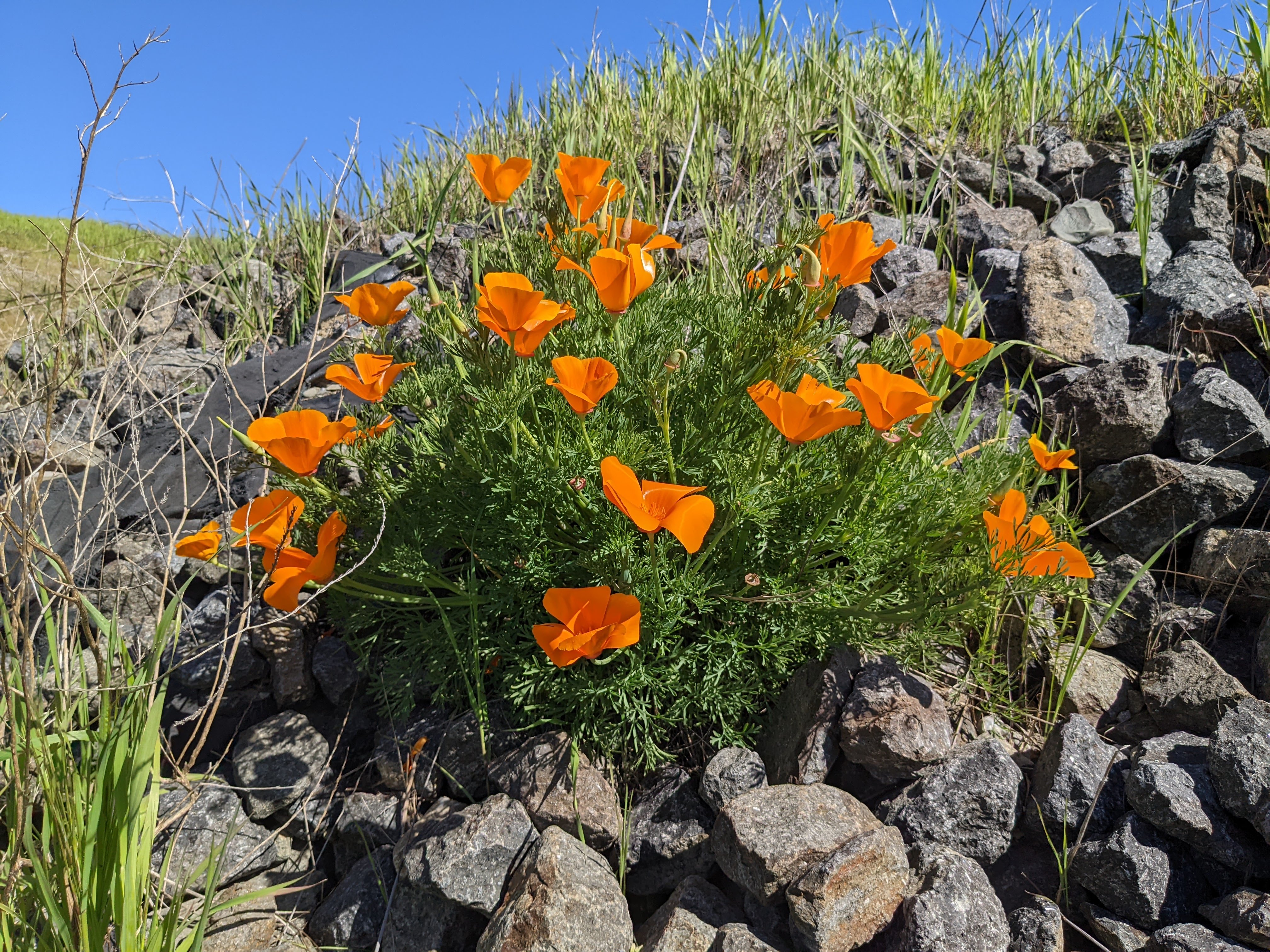
A scenery photo of flowers, trees, mountains, clouds, and Arroyo Del Valle Regional Trail (left).
The flower species in this photo include: Blue Dicks (Dichelostemma capitatum), California Poppies (Eschscholzia californica), Miniature Lupine (Lupinus bicolor), Sticky Monkey Flower (Mimulus aurantiacus).
The photo was shot at the intersection of Arroyo Del Valle Regional Trail, Kingfisher Crossing, and Winery Loop.

A close up photo of flowers, power lines, bee (slightly left from center), and clouds.
The flower species in this photo include: Hairy Vetch (Vicia villosa), Miniature Lupine (Lupinus bicolor), Sticky Monkey Flower (Mimulus aurantiacus).
The photo was shot on Kingfisher Crossing.

A photo of the abandoned Olivina Winery Building. The photo was shot on Winery Loop.

A photo of the abandoned Olivina Winery Building, Winery Loop (left), and trees (left).

This is all the photos for today. I hope you have enjoyed viewing the photos! Please don't forget to share the blog post with your friends and family members! Also, if you want to get notifications when I post up more photos, "Like" us on Facebook or follow me on Instagram. These links can also be found on the top of the right sidebar.

Sunday, April 16, 2023

Pleasanton Ridge Regional Park (Cellphone Photos) - Sunol, CA

Yesterday, on 15 April 2023, my parents and I went hiking in Pleasanton Ridge Regional Park in Sunol, CA. My mom and I hiked to Sunol Peak from Tyler Ranch Staging Area. My dad turned around part of the way up since he hasn't completely recovered from his leg injury a year ago. I took photos with my cellphones. I hope you enjoy viewing the photos.

Before I get started today, I just wanted to tell you about the Midland two way radios I used on this trip to communicate with my dad. I frequently use these radios on my trip because cellphone service isn't always available. On this hike, I used the Midland GXT1050 Radio and my dad used the Midland GXT1030 Radio. Like I said at the beginning, my dad turned back part of the way due to his injuries. There was a short section of trail where the communication came in broken and my mom ended up calling him on his cellphone (he was taking photos around the parking lot and Sunol Downtown). I think there was some interference coming in from other people transmitting, and from that section of trail, there was a severely obstructed line-of-sight (a lot of hills in the way) back to the parking lot. The furthest test my dad and I did was with him in the parking lot (Tyler Ranch Staging Area) and me at Sunol Peak (highest point in Pleasanton Ridge Regional Park). There was mild obstructions back to the parking lot from Sunol Peak (slight hills). The distance was approximately 2.6 miles apart, and we were able to communicate clearly. Please note that two way radios tend to work better when transmitting from mountain peak into a valley. I've used these radios for many years on my trips and I highly recommend them.

A scenery photo of cows, green hills, and the sky. The photo was shot on Sunol Ridge Trail.

A scenery photo of California Poppies (Eschscholzia californica), Long Beaked Filaree Flowers (Erodium botrys), rocks, a green hill, and the sky. The photo was shot on Sunol Ridge Trail.

A photo of California Poppies (Eschscholzia californica), Long Beaked Filaree Flowers (Erodium botrys), and grass. The photo was shot on Sunol Ridge Trail.

A panorama from Sunol Ridge Trail.
Left: Pleasanton, Livermore, Dublin
Center: Sunol, CA
Center Right: Mt. Allison & Mission Peak
Right: SF Bay Area

A scenery photo from Sunol Ridge Trail.
Left: Sunol, Mt. Allison, Mission Peak
Right: SF Bay Area

A scenery photo of State Route 84, Niles Canyon, and the SF Bay Area. The flowers in the photo are California Poppies (Eschscholzia californica) and Long Beaked Filaree Flowers (Erodium botrys). The photo was shot on Sunol Ridge Trail.

A scenery photo of Pleasanton, Livermore, and Dublin. The flowers in the photo are California Poppies (Eschscholzia californica) and Long Beaked Filaree Flowers (Erodium botrys). The photo was shot on Sunol Ridge Trail.

A scenery photo from Sunol Peak. In the distance are San Francisco (left), Mt. Tamalpais (center), and Oakland (right).

A scenery photo from Sunol Peak. In the distance are Union City, Hayward, and San Mateo Bridge (State Route 92).

A scenery photo from Sunol Peak. In the distance are Mt. Allison & Mission Peak (center), cows (bottom right), and SF Bay Area (right).

This is all the photos for today. I hope you have enjoyed viewing the photos! Please don't forget to share the blog post with your friends and family members! Also, if you want to get notifications when I post up more photos, "Like" us on Facebook or follow me on Instagram. These links can also be found on the top of the right sidebar.

Monday, March 27, 2023

Shadow Cliffs Flowers (Cellphone Photos) - Pleasanton, CA

Today, on 27 March 2023, my mom and I took a walk in Shadow Cliffs Regional Park (or Shadow Cliffs Regional Recreation Area) in Pleasanton, CA. I took cellphone photos of flowers on my walk. I hope you enjoy viewing my photos. 

A photo of a California Poppy (Eschscholzia californica).

Advertisement
Advertisement Place Holder APHAPHAPHAPHAPHAPH

A photo of Arroyo Lupine (Lupinus succulentus) flowers.

A photo of California Poppies (Eschscholzia californica).

This is all the photos for today. I hope you have enjoyed viewing the photos! Please don't forget to share the blog post with your friends and family members! Also, if you want to get notifications when I post up more photos, "Like" us on Facebook or follow me on Instagram. These links can also be found on the top of the right sidebar.

Thursday, April 29, 2021

Livermore, CA to Lick Observatory in San Jose, CA (Cellphone Photos)

Yesterday, I took a scenic drive with my mom. We drove from Livermore to San Jose via Mines Road and State Route 130. We visited Lick Observatory. Here are the cellphone photos I took on the drive. I also had some fun and had my mom helped me take some photos of me on this drive too.

A scenery photo from Mines Road in Alameda County, CA. In the photo are horses.

A scenery photo from Mines Road in Santa Clara County, CA. The flowers in the photo are California Poppies (Eschscholzia californica).

Scenery photos from San Antonio Valley Road (State Route 130) in Santa Clara County, CA.

A panorama from San Antonio Valley Road (State Route 130) in Santa Clara County, CA.

Photos of me on the side of San Antonio Valley Road (State Route 130) in Santa Clara County, CA.

Scenery photos from Lick Observatory at the summit of Mount Hamilton. Photos taken on San Antonio Valley Road (State Route 130) in Santa Clara County, CA.

Photos of me at Lick Observatory at the summit of Mount Hamilton. Photos taken on San Antonio Valley Road (State Route 130) in Santa Clara County, CA.

Photos of me at Lick Observatory at the summit of Mount Hamilton. Photos taken on San Antonio Valley Road (State Route 130) in Santa Clara County, CA.

Scenery photos from State Route 130 (Mt. Hamilton Road) in Santa Clara County, CA.

This is all the photos for today. I hope you have enjoyed viewing the photos! Please don't forget to share the blog post with your friends and family members! Also, if you want to get notifications when I post up more photos, "Like" us on Facebook or follow me on Twitter and Instagram. These links can also be found on the top of the right sidebar.