On 12 December 2022, my parents and I took a day trip to Yosemite National Park in California to see snow. Unfortunately we did not get to visit Yosemite Valley on this trip because a rockslide on Big Oak Flat Road blocked Yosemite Valley access from State Route 120. We were pretty disappointed when we saw the news (in Groveland, CA where I went to go buy some lunch), and detouring to State Route 140 would take too long for a day trip. We ended up walking part of the closed Big Oak Flat Road (getting some photos from the long tunnel where you normally can't take photos since there will be vehicles driving in there), and drove around Foresta, CA. The photos are split into 2 blog posts. I hope you enjoy viewing my photos!
Parts: Cellphone Photos | Olympus Photos
These are the photos I took on my cellphone. The photos are from Stanislaus National Forest (first photo), State Route 120, Big Oak Flat Road, and Foresta, CA.
The first stop on our trip was Cocina Michoacana (Mexican Restaurant) in Groveland, CA. I needed to buy myself some lunch for our trip (my parents brought lunch for themselves). I highly recommend the restaurant. The prices were pretty cheap for a tourist town (2 large veggie burritos, chips, and salsa cost me just $30.09), the portions are huge, and the food is good.
I had cell service in Groveland, so I decided to look at the Yosemite webcams online. This was where problem struck. I checked the road conditions before we left the house, and during the drive. I saw everything that was supposed to be open during winter was open. When I opened up the NPS website for the webcams in Yosemite, I saw a huge exclamation mark in a triangle ⚠️ on the top saying no access to Yosemite Valley from State Route 120, and that Big Oak Flat Road was closed at the Foresta Junction. As we drove out of Groveland, the cell service became patchy, and I couldn't figure out why. It puzzled me because I checked the road conditions a few days prior too and Yosemite didn't close State Route 120 and Big Oak Flat Road even during the severe winter storms this past weekend, the same storms that ended up closing State Route 80, 50, and 88, which normally stays open even in mild to moderate winter storms.
When I finally got the road conditions page on the NPS website for Yosemite to load, I saw that Big Oak Flat Road was closed due to a rockslide. Just our luck! 😭 We decided to keep driving forward as we thought maybe it was a small rockslide and they will clear the road in an hour or 2.
I first start off with a photo from Stanislaus National Forest that I took on our drive into Yosemite National Park.
A scenery photo of State Route 120, snow, clouds, and forest. The photo is from the Stanislaus National Forest.
As we kept driving, we saw several vehicles that were in front of us turn back. We decided to continue as we were pretty close to the park, and we can ask the ranger for more information. I have a US National Parks Access Pass due to my visual snow syndrome, moderate to severe PTSD, chronic depression, generalized anxiety, and OCD. My psychiatrist wrote me a letter to get one a few years back because she thinks it will benefit my mental health (and it does). The mental health problems does disable me quite a bit, and visual snow syndrome is just the icing on the cake 😭. My family and I can get into the national parks for free with my Access Pass. The National Parks Access Pass is the only "benefit" I have ever taken for my disabilities.
Next, we entered the park. I talked to the ranger, and he told me that the rockslide won't be cleared for at least a day. After I got home, I took a look at Yosemite's Facebook page, and I'm guessing the road is going to be closed for at least a week. The rockslide was pretty big, and damaged the road along with the foundation underneath the road. It will probably be a while before they can fix it due to the icy and snowy conditions on the road. I'm guessing the conditions are too treacherous for the large machinery that will be required to fix everything. At the time we didn't know, so we took the ranger's word on the estimated timeline. We stayed for a while at the Big Oak Flat Information Station, using the bathroom there, eating our lunch, and calculating how long it would take us to detour to State Route 140 and enter Yosemite Valley from there. Google Maps was showing 2.5 hours and because of the snowy and icy conditions, we knew it would take another extra 30 minutes to an hour. We decided against detouring.
My original backup plan was to snowshoe up to Crane Flat Lookout, however my parents don't have snowshoes and they can't follow me in. I then decided we can drive to the road closure (which was at the Foresta Junction) as there are some nice views along Big Oak Flat Road up to that point.
A scenery photo of State Route 120 (Big Oak Flat Road), snow, clouds, and forest. The photo is from Yosemite National Park.
A scenery photo of snow and forest. The photo was shot on the side of State Route 120 (Big Oak Flat Road) in Yosemite National Park.
A scenery photo of a snow covered tree, snow, and forest. The photo was shot on the side of State Route 120 (Big Oak Flat Road) in Yosemite National Park.
Next we turned off of State Route 120 (Big Oak Flat Road) onto Big Oak Flat Road (the section that isn't State Route 120, as past the Chevron petrol station at Crane Flat, State Route 120 becomes Tioga Road).
A scenery photo of Big Oak Flat Road, fog, snow, and forest. The photo is from Yosemite National Park.
A scenery photo of Big Oak Flat Road, fog, snow, and forest. The photo is from Yosemite National Park.
A scenery photo of snowy mountains, clouds, snow, and forest. The photo was shot on Big Oak Flat Road in Yosemite National Park.
A scenery photo of snowy mountains, clouds, snow, and forest. The photo was shot on Big Oak Flat Road in Yosemite National Park.
A scenery photo of snowy mountains, clouds, snow, and forest. The photo was shot on Big Oak Flat Road in Yosemite National Park.
A scenery photo of snowy mountains, clouds, snow, and forest. The photo was shot on Big Oak Flat Road in Yosemite National Park.
A scenery photo of snowy mountains, clouds, snow, and forest. The photo was shot on Big Oak Flat Road in Yosemite National Park.
A scenery photo of snowy mountains, clouds, snow, and forest. The photo was shot near Big Oak Flat Road Trail Head and Big Oak Flat Road in Yosemite National Park.
A scenery photo of Foresta Road, snowy mountains, clouds, snow, and forest. The photo was shot near Big Oak Flat Road Trail Head and Big Oak Flat Road in Yosemite National Park.
Up next, we arrive at the road closure on Big Oak Flat Road at the Foresta Junction (intersection of Big Oak Flat Road and Foresta Road).
A photo of the road closure at Foresta Junction (intersection of Big Oak Flat Road and Foresta Road) shot on Big Oak Flat Road. In the background are snowy mountains, clouds, snow, and forest. The photo is from Yosemite National Park.
My original plan was to drive around Foresta, CA after hitting the road closure, but before I went with that plan, I had a chat with the 2 other tourists ahead of us (you can see them behind the "Stop" sign on the photo above). They reminded me there was a viewpoint within walking distance right behind the closure, and they told me they were going to walk over there for some photos.
I took a look at my map and realized there were actually 2 viewpoints within walking distance right behind the closure (1 on each side of the long tunnel), and I can walk through the long tunnel on Big Oak Flat Road and take some photos that you normally can't take because there will be vehicles driving through the tunnels and on the roads. My parents and I ducked under the road closure gate and went for our walk.
Note: I do not recommend bypassing road closures. They are there for your safety. If you decide to bypass a road closure, you do so at your own risk. In this case, I knowingly walked into an area that recently had a rockslide. I decided to take that risk, along with my parents and the 2 other tourists. Again, do so at your own risk, and always assess your risks before proceeding.
Up next, we arrive at the first viewpoint on Big Oak Flat Road.
A scenery photo of snowy mountains, clouds, snow, and forest. The photo was shot on Big Oak Flat Road (on the closed section) in Yosemite National Park.
My mom was really cold so she decided to head back to the car. I had 3 Motorola TalkAbout Two Way Radios on me, and I gave her 1 (Motorola TalkAbout T107 Radio -
Product Link - Affiliate Link). I had the other Motorola T107 Radio (
Product Link - Affiliate Link) and my dad had 1 of my Motorola T100 Radios (
Product Link - Affiliate Link). We did some range testing on this walk. I'll tell you a bit more about how our range testing went later in this post.
My dad and I proceeded to walk through the Long Tunnel on Big Oak Flat Road.
A photo of the Long Tunnel on Big Oak Flat Road, forest, and snow. The photo was shot on Big Oak Flat Road (on the closed section) in Yosemite National Park.
A photo of the Long Tunnel on Big Oak Flat Road. The photo was shot on Big Oak Flat Road (on the closed section) in Yosemite National Park.
A photo of the Long Tunnel on Big Oak Flat Road and the forest outside of the tunnel. The photo was shot on Big Oak Flat Road (on the closed section) in Yosemite National Park.
A photo of the Long Tunnel on Big Oak Flat Road and the forest outside of the tunnel. The photo was shot on Big Oak Flat Road (on the closed section) in Yosemite National Park.
A photo of the Long Tunnel on Big Oak Flat Road and the forest outside of the tunnel. The photo was shot on Big Oak Flat Road (on the closed section) in Yosemite National Park.
Both the Motorola T107 Radio (
Product Link - Affiliate Link) and the Motorola T100 Radios (
Product Link - Affiliate Link) failed to communicate with my mom. My dad and I wasn't expecting it to work. We were pretty much in a nuclear bunker in this tunnel with a large granite mountain over us. No RF signals are getting in or out of it. It failed to work as expected. We decided to test them anyways in case the two way radios decided to surprise us.
A photo of a ventilation tunnel for the Long Tunnel. In the background are a snowy mountain and forest. The photo was shot near Big Oak Flat Road (on the closed section) in Yosemite National Park.
Note: I had a headlamp for illuminating the ventilation tunnel. At no time should you blindly enter a tunnel or a cave where you can not see your footing. There could be hidden steep drop offs that you are not aware of. Always make sure you can see where you are going.
I wonder when was the last time someone set foot in this ventilation tunnel. I'm pretty sure it doesn't get much visitors as the Long Tunnel normally have vehicles driving through it and there are no places for a vehicle to park.
A scenery photo from the end of the ventilation tunnel for the Long Tunnel. In the photo are snowy mountains, clouds, snow, and forest. My camera happened to have captured a few drops of water dripping down from above. The photo was shot near Big Oak Flat Road (on the closed section) in Yosemite National Park.
A photo of the Long Tunnel on Big Oak Flat Road and the forest outside of the tunnel. The photo was shot on Big Oak Flat Road (on the closed section) in Yosemite National Park.
Up next, my dad and I arrive at the other viewpoint on the other side of the Long Tunnel on Big Oak Flat Road.
A scenery photo of the Merced River (center), Bridalveil Fall (in the distance in the center), snowy mountains, clouds, snow, and forest. The photo was shot on Big Oak Flat Road (on the closed section) in Yosemite National Park.
My dad and I tested both the Motorola T107 Radio (
Product Link - Affiliate Link) and the Motorola T100 Radios (
Product Link - Affiliate Link). We failed to communicate with my mom. My mom and us were approximately 1.1 miles apart. I'm not too surprised at this result either since these are cheap two way radios, there was a tiny bit of an altitude difference between us, there was a long tunnel and a large granite mountain between us, and we were not in line-of-sight with each other.
My dad and I begin our walk back through the Long Tunnel and back to our car.
A photo of a Motorola TalkAbout T107 Two Way Radio
(Product Link - Affiliate Link) in my hand. The photo was shot on Big Oak Flat Road (on the closed section) in Yosemite National Park.
My dad and I tested both the Motorola T107 Radio (
Product Link - Affiliate Link) and the Motorola T100 Radios (
Product Link - Affiliate Link) after we exited the Long Tunnel. The radios failed to communicate with my mom at approximately 0.5 mile, however started working again at approximately 0.4 mile (with broken communication possible at approximately 0.45 mile). There was a tiny bit of an altitude difference between us, a small part of the large granite mountain was still between us, and we were not in line-of-sight with each other. I was a tiny bit disappointed at both of the two way radios' performance, however they are cheap radios. My parents and I will definitely continue testing and using these radios on our future trips.
Next, we went for a drive around Foresta, CA in Yosemite National Park.
A scenery photo of Crane Creek, snow, and forest. The photo was shot on Foresta Road in Foresta, CA and Yosemite National Park.
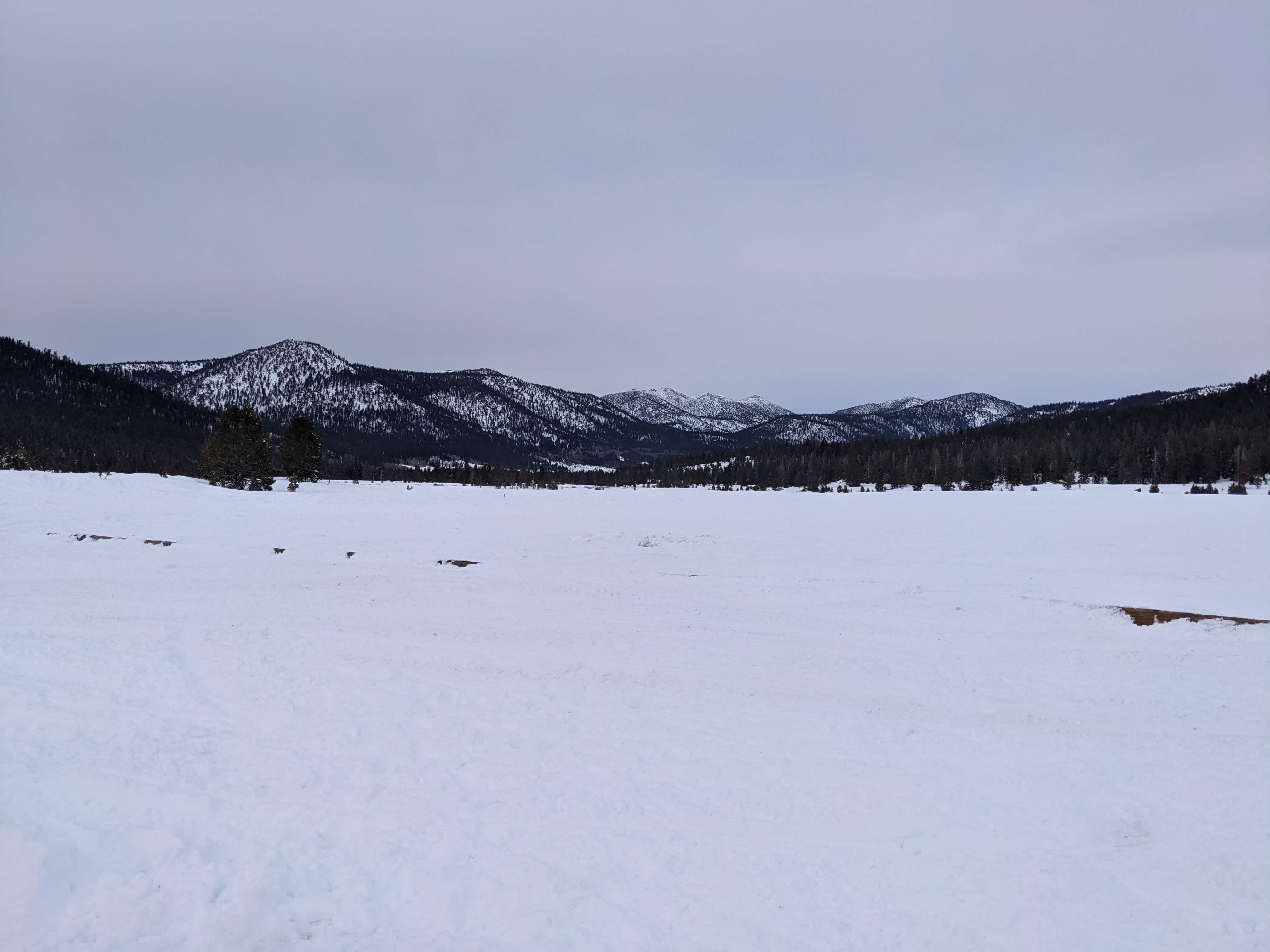
A sunset scenery photo of snowy mountains, clouds, snow, and forest. The photo was shot on Foresta Road in Foresta, CA and Yosemite National Park.
21°F was the lowest temperature we hit on our trip. It was very icy outside. I took this photo on Big Oak Flat Road (State Route 120). I'm still half night blind due to my Visual Snow Syndrome, so I was obviously not driving (just in case you were concerned with this photo). My dad drove.
This is all the photos for today. I hope you have enjoyed viewing the photos! Please don't forget to share the blog post with your friends and family members! Also, if you want to get notifications when I post up more photos, "Like" us on Facebook or follow me on Instagram. These links can also be found on the top of the right sidebar.
Parts: Cellphone Photos | Olympus Photos