Showing posts with label Mammoth Lakes. Show all posts

Sunday, December 4, 2022

Mammoth Lakes & Inyo NF (Canon Pt. 2) - Mammoth Lakes Trip

My parents and I spent 2 nights at Mammoth Lakes, CA between October 21 to October 23 in 2022. We explored Yosemite National Park, Inyo National Forest, Mono County, and Humboldt-Toiyabe National Forest in California enjoying the scenery and autumn foliage. I took photos with my phone, my Olympus mirrorless camera, and my Canon EOS 5D Mark III camera. The photos will be split into several blog posts. I hope you enjoy viewing my photos! 

High Resolution Photos: If you want to see high resolution photos of any of the photos you see here, use the following links. If you wish to purchase prints of any of the photos, please contact me here. To view my best Inyo National Forest & Mono County photos from 2019 to 2022, use this link. To see all of my photos from Inyo National Forest & Mono County on this trip, use this link.

Parts: 

Cellphone: Part 1Part 2 | Part 3

Olympus: Part 1 | Part 2

Canon: Part 1 | Part 2

This is part 2 of the photos that were shot on my Canon DSLR. The photos are from Mammoth Lakes, CA and the Inyo National Forest. The photos are from the various lakes and spots around Mammoth Lakes, CA, Bald Mountain in the Inyo National Forest, and more.

This blog post contains photos I took on day 3, the last day of my trip. On our last day, we explored Mammoth Lakes, CA visiting several locations in the town, including the various lakes surrounding the town in the bordering Inyo National Forest. We also drove up Bald Mountain in the Inyo National Forest in California. After Bald Mountain, we visited Virginia Lakes in the Humboldt-Toiyabe National Forest in California (cellphone photos only) before heading home.

Our first stop of the day was Minaret Vista in the Inyo National Forest. We visited the vista on day 2 as well, but because of the heavy snowstorm in Mammoth Lakes and the Sierra Nevada mountains, we literally drove into a cloud, and was not able to see anything. On day 2, Minaret Vista was a total white-out. Since I knew the view would be really nice in good weather (thanks to Google Maps), I decided to give it another try on the last day of our trip.

A scenery photo of forest and the Sierra Nevada mountain range. The photo was shot at Minaret Vista in the Inyo National Forest.
Approximate GPS location (type into Google): 37° 39' 23" N 119° 03' 41" W

After Minaret Vista, we went to go explore the various lakes around Mammoth Lakes in the Inyo National Forest.

A scenery photo of forest and Glass Mountain Ridge (in the distance). The photo was shot on Lake Mary Road (near Twin Lakes Vista) in Mammoth Lakes, CA/Inyo National Forest.
Approximate GPS location (type into Google): 37° 37' 30" N 119° 00' 21" W

A scenery photo of Lake Mary and Mammoth Crest (in the distance). The photo was shot near Lake Mary Road in Mammoth Lakes, CA/Inyo National Forest.
Approximate GPS location (type into Google): 37° 36' 21" N 119° 00' 11" W

A scenery photo of Lake Mary and Mammoth Mountain. The photo was shot on the Lake Mary Marina Pier at Lake Mary Marina in Mammoth Lakes, CA/Inyo National Forest.
Approximate GPS location (type into Google): 37° 36' 00" N 118° 59' 59" W

After we were done exploring the lakes, we explored various spots in Mammoth Lakes, CA and looked at the autumn foliage in town.

A scenery photo of Mammoth Lakes, CA, Glass Mountain Ridge (in the distance on the left), and White Mountains (in the distance on the right). The photo was shot at The Bluffs on Le Verne Street in Mammoth Lakes, CA.
Approximate GPS location (type into Google): 37° 37' 22" N 118° 59' 06" W

A scenery photo of Mammoth Lakes, CA, Glass Mountain Ridge (in the distance on the left), and White Mountains (in the distance on the right). The photo was shot at The Bluffs on Le Verne Street in Mammoth Lakes, CA.
Photo shot at the same spot as above.

A scenery photo of autumn foliage on aspen trees. The photo was shot near Old Mammoth Road in Mammoth Lakes, CA.
Approximate GPS location (type into Google): 37° 37' 57" N 118° 58' 25" W

A scenery photo of autumn foliage on aspen trees. The photo was shot near Old Mammoth Road in Mammoth Lakes, CA.
Approximate GPS location (type into Google): 37° 37' 58" N 118° 58' 25" W

A scenery photo of autumn foliage on aspen trees. The photo was shot near Timber Creek Road in Mammoth Lakes, CA.
Approximate GPS location (type into Google): 37° 37' 56" N 118° 58' 30" W

A black and white process of the photo above.

A scenery photo of autumn foliage on aspen trees and Timber Creek Road. The photo was shot in Mammoth Lakes, CA.
Approximate GPS location (type into Google): 37° 37' 54" N 118° 58' 31" W

A scenery photo of autumn foliage on aspen trees and Timber Creek Road. The photo was shot in Mammoth Lakes, CA.
Approximate GPS location (type into Google): 37° 37' 55" N 118° 58' 31" W

A scenery photo of autumn foliage on aspen trees. The photo was shot near the intersection of Timber Creek Road and Old Mammoth Road in Mammoth Lakes, CA.
Approximate GPS location (type into Google): 37° 37' 55" N 118° 58' 27" W

Up next, we left Mammoth Lakes, and drove up to Bald Mountain Lookout on Bald Mountain in the Inyo National Forest.

Travel Tip: You may need a vehicle with moderate clearance to make it up the last 1.5 miles of dirt and gravel road up to Bald Mountain Lookout. Our family drives a 2006 Honda Pilot and we made it all the way up. The road to Bald Mountain Lookout is not paved, so you will be driving a little over 11 miles on dirt and gravel roads after you turn off of US Route 395. The road is very wide and in fairly good condition with exception to the last 1.5 miles. The hard part starts at the intersection of Bald Mountain Road and Bald Mountain Springs Road (Forest Road 02S481). The last 1.5 miles of Bald Mountain Road (Forest Road 02S162) is really steep, rocky, bumpy, and most of it is only wide enough for 1 vehicle to pass through. As you get close to Bald Mountain Lookout, there is another dirt road that splits from the main road (Forest Road 01S05H) that will lead you to another (lower) peak, but the road looks very narrow, rough, primitive, and only passable with an OHV (SxS), dirt bike, or mountain bike. Don't forget, the vehicle driving uphill always has the right-of-way. We were here on a Sunday, and we only saw 1 other vehicle on our drive in. Looking at the guestbook in the Bald Mountain Warming Hut, there were only 2 signatures (1 for each day) for the 2 days prior, so you will most likely not meet anyone on your drive. Bald Mountain Lookout is only accessible via snowmobiles, backcountry skiing, or snowshoeing when the road is covered in snow.

A scenery photo of Mono Lake (in the distance), Paoha Island (in the distance on the left), Eastern Sierras (left), and forest. The photo was shot at Bald Mountain Lookout on Bald Mountain in the Inyo National Forest.
Approximate GPS location (type into Google): 37° 47' 03" N 118° 54' 06" W

A scenery photo of Eastern Sierras (in the distance) and forest. The photo was shot at Bald Mountain Lookout on Bald Mountain in the Inyo National Forest.
Photo shot near the same spot as above.

A scenery photo of Mono Lake & Paoha Island (in the distance on the right), Eastern Sierras (in the distance on the left), and forest. The photo was shot at Bald Mountain Lookout on Bald Mountain in the Inyo National Forest.
Photo shot near the same spot as above.

A scenery photo of Eastern Sierras (in the distance), Lake Crowley (in the distance on the left), and Mammoth Yosemite Airport (in the distance in the center). The photo was shot at Bald Mountain Lookout on Bald Mountain in the Inyo National Forest.
Approximate GPS location (type into Google): 37° 47' 00" N 118° 54' 05" W

A black and white process of the photo above.

A scenery photo of Mono Lake (in the distance), Paoha Island (in the distance in the center), Eastern Sierras (in the distance on the left), and forest. The photo was shot at Bald Mountain Lookout on Bald Mountain in the Inyo National Forest.
Approximate GPS location (type into Google): 37° 47' 03" N 118° 54' 06" W

After enjoying the scenery at Bald Mountain, we began our drive to Virginia Lakes in the Humboldt-Toiyabe National Forest (cellphone photos only). Before we got there, we stopped by West Portal Scenic View Point/Aeolian Buttes Viewpoint (Forest Road 01S116) on the side of US-395 in the Inyo National Forest.

A scenery photo of Mono Lake (in the distance), Paoha Island (in the distance on the right), and Negit Island (in the distance slightly right of the center). The photo was shot at West Portal Scenic View Point/Aeolian Buttes Viewpoint (Forest Road 01S116) in the Inyo National Forest.
Approximate GPS location (type into Google): 37° 50' 35" N 119° 04' 03" W

After Virginia Lakes in the Humboldt-Toiyabe National Forest (cellphone photos only), we drove home via State Route 108 (Sonora Pass).

This is all the photos for today. I hope you have enjoyed viewing the photos! Please don't forget to share the blog post with your friends and family members! Also, if you want to get notifications when I post up more photos, "Like" us on Facebook or follow me on Instagram. These links can also be found on the top of the right sidebar.

Parts: 

Cellphone: Part 1Part 2 | Part 3

Olympus: Part 1 | Part 2

Canon: Part 1 | Part 2

Thursday, October 27, 2022

Mammoth Lakes & Inyo NF (Phone Pt. 2) - Mammoth Lakes Trip

My parents and I spent 2 nights at Mammoth Lakes, CA between October 21 to October 23 in 2022. We explored Yosemite National Park, Inyo National Forest, Mono County, and Humboldt-Toiyabe National Forest in California enjoying the scenery and autumn foliage. I took photos with my phone, my Olympus mirrorless camera, and my Canon EOS 5D Mark III camera. The photos will be split into several blog posts. I hope you enjoy viewing my photos! 

Parts: 

Cellphone: Part 1 | Part 2 | Part 3

Olympus: Part 1 | Part 2

Canon: Part 1 | Part 2

These photos were shot on my cellphone. The photos are from Mammoth Lakes, CA and the Inyo National Forest. There were still some autumn foliage left at Mammoth Lakes on our last day, and my parents and I had a great time viewing them.

On day 3, we mostly explored Mammoth Lakes and the surrounding lakes, but also dropped by Bald Mountain and Virginia Lakes on the way home (the photos from the latter 2 will be in part 3).

A scenery photo of Twin Lakes, Mammoth Crest (in the distance), and forest shot at Twin Lakes Vista. The photo is from the Inyo National Forest and Mammoth Lakes, CA.

A scenery photo of Lake Mamie, Mammoth Crest (in the distance), and forest shot at Lake Mamie Vista Point. The photo is from the Inyo National Forest and Mammoth Lakes, CA.

A scenery photo of Twin Lakes, mountains and forest shot at Twin Lakes Vista Point. The photo is from the Inyo National Forest and Mammoth Lakes, CA.

A scenery photo of Horseshoe Lake, Mammoth Crest (right), mountains, and forest. The photo is from the Inyo National Forest and Mammoth Lakes, CA.

A scenery photo of Lake George, Mammoth Crest, and forest. The photo is from the Inyo National Forest and Mammoth Lakes, CA.

A scenery photo of Lake Mary, mountains, and forest. The photo is from the Inyo National Forest and Mammoth Lakes, CA.

A scenery photo of Lake Mary, mountains, and forest. The photo is from the Inyo National Forest and Mammoth Lakes, CA.

A panorama of Lake Mary, Mammoth Mountain (center), and forest. The photo is from Lake Mary Marina in the Inyo National Forest and Mammoth Lakes, CA.

A scenery photo of Glass Mountain Ridge (left), White Mountains (right), and forest. The photo is from Old Mammoth Road in the Inyo National Forest and Mammoth Lakes, CA.

A scenery photo of autumn foliage. The photo is from the intersection of Old Mammoth Road and Tamarack Street in Mammoth Lakes, CA.

A scenery photo of autumn foliage. The photo is from Tamarack Street in Mammoth Lakes, CA.

A scenery photo of autumn foliage and the Eastern Sierras. The photo is from the intersection of Old Mammoth Road and Tamarack Street in Mammoth Lakes, CA.

A photo of a historic cabin from Mammoth Museum at the Hayden Cabin in Mammoth Lakes, CA.

A scenery photo of the Eastern Sierras and forest from Mammoth Museum at the Hayden Cabin in Mammoth Lakes, CA.

A photo from Mammoth Museum at the Hayden Cabin in Mammoth Lakes, CA.

A scenery photo of autumn foliage. The photo is from near Old Mammoth Road in Mammoth Lakes, CA.

A scenery photo of autumn foliage, a golf course, and Eastern Sierras. The photo is from Snowcreek Golf Course in Mammoth Lakes, CA.

A scenery photo of autumn foliage, a golf course, and Eastern Sierras (right). The photo is from Snowcreek Golf Course in Mammoth Lakes, CA.

After Snowcreek Golf Course, my parents and I left Mammoth Lakes, CA. On the way home we visited Bald Mountain and Virginia Lakes (photos in part 3).

This is all the photos for today. I hope you have enjoyed viewing the photos! Please don't forget to share the blog post with your friends and family members! Also, if you want to get notifications when I post up more photos, "Like" us on Facebook or follow me on Twitter and Instagram. These links can also be found on the top of the right sidebar.

Parts: 

Cellphone: Part 1 | Part 2 | Part 3

Olympus: Part 1 | Part 2

Canon: Part 1 | Part 2

Tuesday, October 25, 2022

Yosemite NP, Inyo NF, Mono County (Phone Pt. 1) - Mammoth Lakes Trip

My parents and I spent 2 nights at Mammoth Lakes, CA between October 21 to October 23 in 2022. We explored Yosemite National Park, Inyo National Forest, Mono County, and Humboldt-Toiyabe National Forest in California enjoying the scenery and autumn foliage. I took photos with my phone, my Olympus mirrorless camera, and my Canon EOS 5D Mark III camera. The photos will be split into several blog posts. I hope you enjoy viewing my photos! 

Parts: 

Cellphone: Part 1 | Part 2 | Part 3

Olympus: Part 1 | Part 2

Canon: Part 1 | Part 2

These photos were shot on my cellphone. The photos are from Yosemite National Park, Inyo National Forest, and Mono County, CA. The photos are from Inyo Craters, Earthquake Fault, Hot Creek Geologic Site, Lake Crowley, and more. 

On day 1, we drove to Mammoth Lakes, CA from the SF Bay Area via State Route 120 through Yosemite National Park.

A scenery photo of autumn foliage shot on the side of Tioga Road (SR-120) in Yosemite National Park.

That concludes my day 1 photos from my cellphone. Day 2 of our trip was extremely windy. I think I probably experienced gusts around 50 MPH. That was definitely not fun, and it was the first time I experienced anything like this. I was barely able to stand at times, the wind knocked down my heavy camera tripod several times (with my camera removed), and almost knocked my heavy camera tripod (with my camera on it) several times. I occasionally leave my camera and tripod to the side when I'm taking photos, texting, or posting on social media. I learned pretty fast that I had to hold onto my camera and tripod outside even when I'm not using it. There were times I had to hunker down, squat down, and make myself as small as possible to wait out a gust as to not lose my balance and injure myself. 

Day 2 started off with heavy wind and rain, followed by heavy wind and snow in Mammoth Lakes, CA. I was super disappointed.

A scenery photo of a crater at Inyo Craters in the Inyo National Forest.

Inyo Craters were formed somewhere between 550 to 650 years ago (1350 CE) by volcanic eruption.

The wind at Inyo Craters was intense. At this point, it was only raining. The main trail runs on the edge of the crater, so on that day I actually went off the trail a tiny bit because the wind kept trying to push me into the crater. It was quite dangerous. I didn't end up taking any photos with my Canon because by the time I got set up, the front of my lens is going to get soaked, and I didn't take any photos of my Olympus because it has no weather protection.

A scenery photo of forest and clouds. The photo is from Inyo Craters Trail in the Inyo National Forest.

A scenery photo of Earthquake Fault in the Inyo National Forest and Mammoth Lakes, CA.

The Earthquake Fault was formed by earthquakes. The age of the fissure caused by the earthquakes is not know, but according to the US Forest Service, some of the trees growing around it are 160 years old, so the fissure is at least that age.

After Inyo Craters, I arrived at Earthquake Fault. The rain turned into snow and rain at this point. The wind in this area wasn't too bad as the area was somewhat sheltered by all the trees.

A scenery photo of Earthquake Fault in the Inyo National Forest and Mammoth Lakes, CA.

A scenery photo of Earthquake Fault in the Inyo National Forest and Mammoth Lakes, CA.

After Earthquake Fault, our family drove up to Minaret Vista in Inyo National Forest. I didn't end up taking any photos here on my 2nd day as it was a complete white-out. As we drove up the mountain, the temperature dropped -2°C (28°F), and we drove right into a cloud. It was snowing outside and the wind was very intense. We were not the only ones to drive up there just to leave disappointed. We saw 2 other vehicles drive away from the vista point before us and 3 other vehicles driving in as we were leaving. The only thing I got to do over here was take a piss.

At this point, I got very worried. I thought my plans for the 2nd day was ruined. My dad also felt hopeless, and even suggested we go back to to hotel to get a nap in (we didn't sleep too well the first night due to mild altitude sickness). My mom had hope and said she thinks it won't be storming this bad out in the desert. I ended up changing the plans, and instead of viewing autumn foliage, I decided to go view the hot springs and Lake Crowley out in the desert.

A scenery photo of Hot Creek Hatchery Road, clouds, mountains, and the desert. The photo is shot in the Inyo National Forest. In the distance you can see the snowstorm and rainstorm in the Sierra Nevada mountains. Also in the photo are the Mammoth Yosemite Airport (in the distance) and Hot Creek Trout Hatchery (in the distance on the right).

My mom was right! The rainstorms and snowstorms did not hit the desert. The rain and snow cleared up as we drove out of Mammoth Lakes, CA into the desert. In fact it was quite sunny in some areas. That is where the good news ends. The wind actually got worse when we got into the desert. Due to the intense winds, every minute or 2, a gust would bring in some snow and rain from the Sierra Nevada mountains. My face got sandblasted by snow quite a bit, and a few times by sand. This was quite an experience and I have never experienced anything like this before in my travels. It was somewhat interesting.

I climbed a rocky hill on the side of Hot Creek Hatchery Road to get that photo above. I had to squat down for a while (and keep a good grip on my camera tripod) to ride out an intense gust of wind before I was able to get back down to our car. If I tried to climb down in that wind, I would have most likely lost my balance and got blown over.

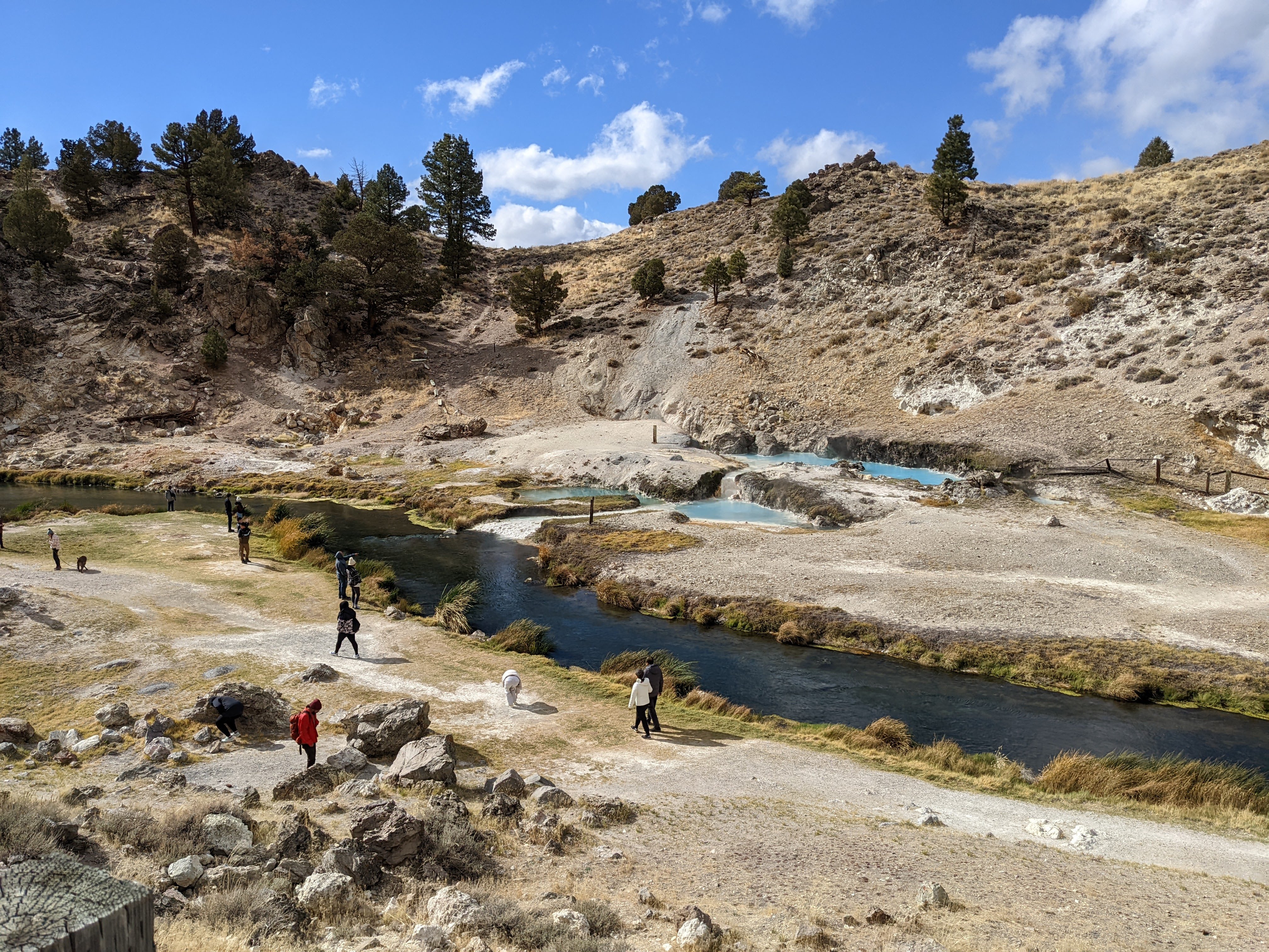
A scenery photo of Hot Creek and the hot spring from Hot Creek Geologic Site in Inyo National Forest. This is a natural hot spring in the desert.

A scenery photo of Hot Creek and the hot spring from Hot Creek Geologic Site in Inyo National Forest. This is a natural hot spring in the desert.

A scenery photo from Brees Lookout over looking Hot Creek, Hot Creek Geologic Site, and the Eastern Sierras (in the distance) in the Inyo National Forest.

A scenery photo of the Eastern Sierras (in the distance), desert, clouds, and mountains from Forest Road 30E304 in the Inyo National Forest.

A scenery photo of the desert, rocks, and clouds from the intersection of Benton Crossings Road and Forest Road 30E304 in the Inyo National Forest.

A scenery photo of the Eastern Sierras (in the distance), desert, clouds, and mountains from Owens Gorge Road in the Inyo National Forest. In the distance you can see the snowstorm and rainstorm in the Sierra Nevada mountains.

A panorama of Lake Crowley, Glass Mountain Ridge (in the distance), White Mountains (in the distance on the right), and clouds shot at a vista point on the side of US-395 in Mono County, CA.

A scenery photo of Lake Crowley, Glass Mountain Ridge (in the distance), White Mountains (in the distance on the right), and clouds shot at a vista point on the side of US-395 in Mono County, CA.

A scenery photo of Lake Crowley, Glass Mountain Ridge (in the distance), and clouds shot at a vista point on the side of US-395 in Mono County, CA.

That concludes my day 2 photos from my cellphone. The bad weather cleared up the next day and the wind mostly died down. Unfortunately that also means all the pretty clouds in the sky was gone. The mountain tops got a very light dusting of snow.

The first stop on day 3 (final day) was Minaret Vista, the vista point we weren't able to see on day 2 due to poor weather.

A photo of the sign at Minaret Vista in the Inyo National Forest. The viewpoint is at 2824 m (9265 ft).

A panorama of mountains and forest from Minaret Vista in the Inyo National Forest.

A scenery photo of mountains and forest from Minaret Vista in Inyo National Forest.

A photo of a snow maker and Mammoth Mountain at the Mammoth Mountain Ski Area. The photo was shot on the side of Minaret Road in the Inyo National Forest and Mammoth Lakes, CA.

This is all the photos for today. I hope you have enjoyed viewing the photos! Please don't forget to share the blog post with your friends and family members! Also, if you want to get notifications when I post up more photos, "Like" us on Facebook or follow me on Twitter and Instagram. These links can also be found on the top of the right sidebar.

Parts: 

Cellphone: Part 1 | Part 2 | Part 3

Olympus: Part 1 | Part 2

Canon: Part 1 | Part 2