Showing posts with label angel island. Show all posts

Saturday, January 28, 2023

Mt. Tamalpais East Peak (Part 2) - Marin County, CA

On 28 December 2022, my parents and I took a day trip to Mount Tamalpais State Park in Marin County, CA. We visited Trojan Point and Mt. Tamalpais East Peak. Recently, it has been raining quite heavily in the San Francisco Bay Area, and we took this trip on a day where there was a break from the storms. It was quite foggy and cloudy on the day we went. You'll see a lot of clouds and fog in the photos. The photos are split into 3 blog posts. I hope you enjoy viewing my photos!

High Resolution Photos: If you want to see high resolution photos of any of the photos you see here, use the following links. If you wish to purchase prints of any of the photos, please contact me here. To view my best Mt. Tamalpais State Park  photos, use this link. To see all of my photos from Mt. Tamalpais State Park & Bolinas, CA from 2016 to 2022, use this link.

Parts: Cellphone Photos | Olympus Part 1 | Olympus Part 2

This is part 2 of the photos I took with my Olympus mirrorless camera. The photos are of sunset and were shot on Verna Dunshee Trail at Mt. Tamalpais East Peak.

A scenery photo of Bon Tempe Lake (left), forest, clouds, and fog.
Approximate GPS location (type into Google): 37° 55' 47" N 122° 34' 44" W

A black and white process of the photo above.

An abstract process of the photo above.

A scenery photo of Bon Tempe Lake (left), forest, clouds, and fog.
Photo shot near the same spot as above.

A scenery photo of the SF Bay Area, forest, clouds, and fog.
In the Photo: Angel Island (left), Sausalito (right), Treasure Island & Yerba Buena Island (in the distance on the left), Bay Bridge & Alcatraz Island (in the distance in the center), and San Francisco (in the distance on the right).
Approximate GPS location (type into Google): 37° 55' 45" N 122° 34' 35" W

An abstract process of the photo above.

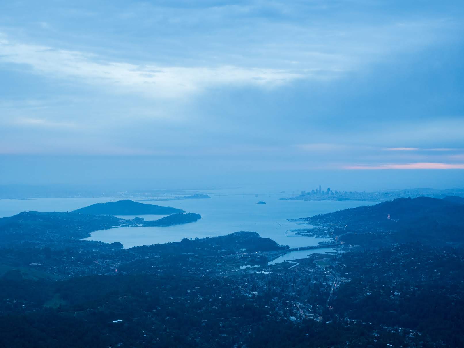
A scenery photo of the SF Bay Area, forest, clouds, and fog.
In the Photo (foreground): Mill Valley, Angel Island, Marin City, and Sausalito.
In the Photo (in the distance): Richmond (left), Treasure Island, Yerba Buena Island, Bay Bridge (center), Alcatraz Island, San Francisco, and Golden Gate Bridge (right).
Approximate GPS location (type into Google): 37° 55' 38" N 122° 34' 35" W

A black and white process of the photo above.

An abstract process of the photo above.

A scenery photo of the SF Bay Area, forest, clouds, and fog.
In the Photo (foreground): San Rafael, Corte Madera Creek (left), and Corte Madera (center).
In the Photo (in the distance): Richmond-San Rafael Bridge, San Quentin State Prison, and Richmond.
Photo shot near the same spot as above.

A black and white process of the photo above.

An abstract process of the photo above.

This is all the photos for today. I hope you have enjoyed viewing the photos! Please don't forget to share the blog post with your friends and family members! Also, if you want to get notifications when I post up more photos, "Like" us on Facebook or follow me on Instagram. These links can also be found on the top of the right sidebar.

Parts: Cellphone Photos | Olympus Part 1 | Olympus Part 2

Thursday, December 29, 2022

Mt. Tamalpais East Peak (Cellphone Photos) - Marin County, CA

On 28 December 2022, my parents and I took a day trip to Mount Tamalpais State Park in Marin County, CA. We visited Trojan Point and Mt. Tamalpais East Peak. Recently, it has been raining quite heavily in the San Francisco Bay Area, and we took this trip on a day where there was a break from the storms. It was quite foggy and cloudy on the day we went. You'll see a lot of clouds and fog in the photos. The photos are split into 2 blog posts. I hope you enjoy viewing my photos!

Parts: Cellphone Photos | Olympus Part 1 | Olympus Part 2

These are the panoramas I took on my cellphone during sunset. The panoramas are from Verna Dunshee Trail at Mt. Tamalpais East Peak. All of the panoramas in this blog post are scenery photos of the San Francisco Bay Area.

In the distance in the panorama:
Right: Richmond-San Rafael Bridge

In the distance in the panorama:
Left: Richmond-San Rafael Bridge
Center: Angel Island & Treasure Island
Slightly Right From Center: San Francisco & Sausalito
Right: Ocean Beach

In the distance in the panorama:
Left: Richmond-San Rafael Bridge
Center: Angel Island, Treasure Island, San Francisco, Sausalito
Slightly Right From Center: Ocean Beach

This is all the photos for today. I hope you have enjoyed viewing the photos! Please don't forget to share the blog post with your friends and family members! Also, if you want to get notifications when I post up more photos, "Like" us on Facebook or follow me on Instagram. These links can also be found on the top of the right sidebar.

Parts: Cellphone Photos | Olympus Part 1 | Olympus Part 2

Saturday, December 28, 2019

On Top Of Coit Tower (Part 2) - San Francisco, CA

On September 1st, 2019, I took a trip to San Francisco, CA. I visited Asian Art Museum (I didn't take photos at this location), Civic Center, and went to the top of Coit Tower for the first time despite living in the San Francisco Bay Area for over a decade now. The photos are split into 4 blog posts. I hope you enjoy viewing these photos.

Full Resolution Photos: If you want to see full resolution photos of any of the photos you see here, use the following links. If you wish to purchase prints of any of the photos, please contact me here. To view my best San Francisco photos taken in 2019, use this link. To view all of my photos from this trip, use this link.

Parts: 1 | 2 | 3 | 4

This is part 2 of my photos. I have more photos taken from the top of Coit Tower.

Message From The Photographer: If you've been following me on social media, you'd know I've been dealing with vision impairment and gradual vision loss since August 2018. The conditions are neurological, so my vision isn't impaired the same amount on a daily basis, but overall it seems to be going down hill. It has slowed down and made taking photos, processing photos, using computers, etc... very challenging and somewhat depressing. Some days it is impossible for me to take photos or process them. I know these photos are from a very long time ago, but I'm only just starting to get around in processing them as I'm only able to work on them at a very slow pace. I hope you can understand, and I hope you enjoy viewing these photos.

In the foreground of this photo are the piers.
In the distance of the photo are Richmond-San Rafael Bridge (left), Richmond, CA (center and right), and Treasure Island (right).

Black and white process of the photo above.

In the foreground of this photo is Treasure Island.

Black and white process of the photo above.

 In the foreground in the photo are Fishermans Wharf (left), Pier 39 (center), and the piers (left).
In the distance of the photo are the North Bay (center and left), Alcatraz Island and Angel Island (slightly left from center), and Richmond-San Rafael Bridge (right).

Black and white process of the photo above.

Scenery of Pier 39 and Alcatraz Island (top left).

Black and white process of the photo above.

In the foreground of the photo is Pier 39.
In the distance of the photo are the North Bay (top center and top left), Alcatraz Island and Angel Island (slightly left from top center), and Richmond-San Rafael Bridge (top right).

Black and white process of the photo above.

Scenery of Golden Gate Bridge and Presidio (center), Lombard Street (left), and Aquatic Park and Hyde Street Pier (right).

Black and white process of the photo above.

In the foreground of the photo are Fishermans Wharf (center), and Aquatic Park and Hyde Street Pier (left).
In the distance of the photo are Golden Gate National Recreation Area (left) and Sausalito, CA (center).

Black and white process of the photo above.

In the foreground of the photo are Fishermans Wharf (center), and Aquatic Park and Hyde Street Pier (left).
In the distance of the photo are Golden Gate National Recreation Area (left) and Sausalito, CA (center).

Black and white process of the photo above.

In the photo are Filbert Street (#1 street from left), Greenwich Street (#2 street from left), Lombard Street (#3 street from left), Chestnut Street (#4 street from left), and Presidio (in the distance on the right).

Black and white process of the photo above.

This is all the photos for today. I hope you have enjoyed viewing the photos! Next time I have more photos shot from the top of Coit Tower. Also, if you want to get notifications when I post up more photos, "Like" us on Facebook or follow me on Twitter and Instagram. These links can also be found on the top of the right sidebar.

Parts: 1 | 2 | 3 | 4