It is very rare to see snow in the San Francisco Bay Area, but the weather recently has been very weird. It snowed like crazy in the San Francisco Bay Area. On February 23 and 24, 2023, my mom and I went to several locations in San Ramon, CA and Danville, CA to go see snow on Mt. Diablo, Mission Peak, Mt. Allison, and more. The places we visited are Forest Home Farms Historic Park (I went to this park mainly to see the sheep and use the bathroom 😅), Bishop Ranch Regional Preserve, Memorial Park, and Sycamore Valley Regional Preserve. I took photos with my cellphones and mirrorless camera. The photos are split into 3 blog posts. I hope you enjoy viewing my photos!
Parts: Cellphone Photos | Olympus Photos (Day 1) | Olympus Photos (Day 2)
These photos were shot on my cellphones.
I first start off with the cellphone photos I took on February 23, 2023.
The first location we went to was Forest Home Farms Historic Park in San Ramon, CA (19953 San Ramon Valley Blvd, San Ramon, CA 94583). I knew I wouldn't be able to see Mt. Diablo from this location. I mostly came here to see the Tractor Museum (which was closed unfortunately), the sheep, and also to use the bathroom.
A photo of sheep, houses, high voltage lines, and clouds.
The photo is from Forest Home Farms Historic Park in San Ramon, CA. The photo was shot on 23 February, 2023.
A photo of historic farm equipment near the Tractor Museum, high voltage lines and clouds.
The photo is from Forest Home Farms Historic Park in San Ramon, CA. The photo was shot on 23 February, 2023.
A photo of sheep, houses, high voltage lines, and clouds.
The photo is from Forest Home Farms Historic Park in San Ramon, CA. The photo was shot on 23 February, 2023.
A photo of sheep, houses, high voltage lines, a church, and clouds.
The photo is from Forest Home Farms Historic Park in San Ramon, CA. The photo was shot on 23 February, 2023.
A photo of sheep, houses, high voltage lines, a church, and clouds.
The photo is from Forest Home Farms Historic Park in San Ramon, CA. The photo was shot on 23 February, 2023.
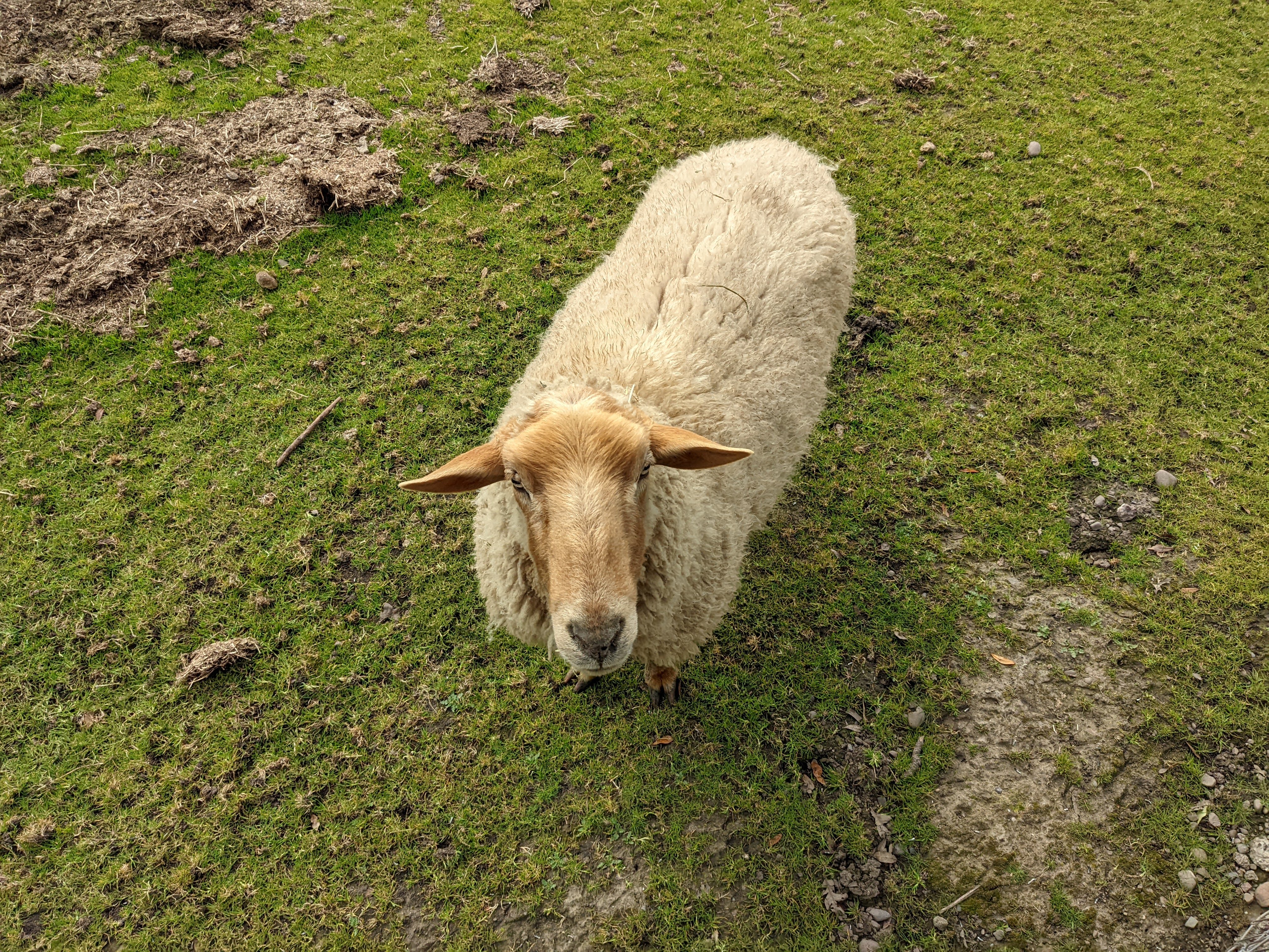
A photo of a sheep.
The photo is from Forest Home Farms Historic Park in San Ramon, CA. The photo was shot on 23 February, 2023.
The second location we went to was Bishop Ranch Regional Preserve in San Ramon, CA.
A photo shot through my monocular.
A photo of Mt. Diablo with a light dusting of snow, and clouds.
The photo is from Redtail Hawk Trail in Bishop Ranch Regional Preserve in San Ramon, CA. The photo was shot on 23 February, 2023.
Up next, are the cellphone photos I took on February 24, 2023. Yes, I know I'm mixing my date formats. I grew up in China, where we used a different format (YYYY/MM/DD | 年/月/日), and then I was taught British date format (DD/MM/YYYY) along with British English. Some habits are hard to break. 😂 In fact, my British accent occasionally comes back into play. I also have an easier time understanding British English than American English.
The first location we went to was Bishop Ranch Regional Preserve in San Ramon, CA. The trail was way too muddy and steep for me to make the climb again (unlike the day before). I attempted a small part of it, but gave up trying to hike Bishop Ranch just a tiny bit past the gate. It would have been too dangerous to hike that steep hill. The reason I was able to hike up Bishop Ranch the previous day was because the first round of rainstorms and snowstorms mainly hit the Peninsula and the South Bay. The Tri-Valley Area didn't get too severe of storms during the first round. Once the second round of storms came in, many of the hiking trails here became very muddy. After abandoning the Bishop Ranch hike, I took a photo near the entrance to the preserve on Morgan Drive.
A scenery photo of snow covered Mt. Diablo, San Ramon, houses, trees, and clouds.
The photo is from Morgan Drive in San Ramon, CA. The photo was shot on 24 February, 2023.
The second location we went to was Memorial Park in San Ramon, CA. After hearing how loud that rainstorm was the previous night, I kind of expected not being able to hike Bishop Ranch Regional Preserve, so I had several backup locations on hand.
A scenery photo of snow covered Mt. Diablo, San Ramon, houses, trees, and clouds.
The photo is from Memorial Park in San Ramon, CA. The photo was shot on 24 February, 2023.
The third location we went to was Sycamore Valley Regional Preserve in Danville, CA. The trails were extremely muddy and it was one of the most challenging hikes I have ever done. I would not recommend you attempt this even with hiking poles. You will see later in the blog post just how muddy it was, and how caked up in mud my shoes, my hiking poles, and my camera tripod was. Those rainstorms and snowstorms the previous night were really severe.
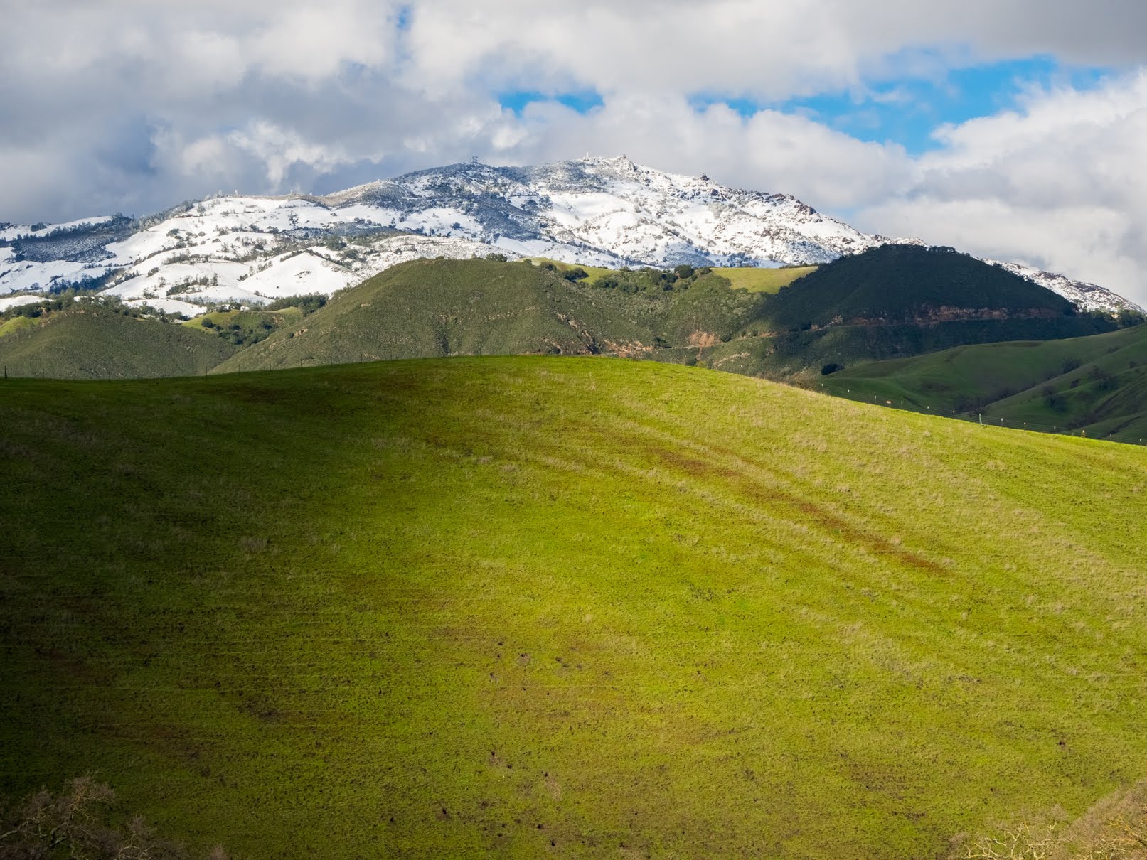
A scenery photo of snow covered Mt. Diablo, green hills, and clouds.
The photo is from Short Ridge Trail in Sycamore Valley Regional Preserve in Danville, CA. The photo was shot on 24 February, 2023.
A photo shot through my monocular.
A photo of snow covered Mt. Allison (left) & Mission Peak (right), green hills, forest, and clouds.
The photo is from Short Ridge Trail in Sycamore Valley Regional Preserve in Danville, CA. The photo was shot on 24 February, 2023.
A photo shot through my monocular.
A photo of snow covered Mt. Diablo and clouds.
The photo is from Short Ridge Trail in Sycamore Valley Regional Preserve in Danville, CA. The photo was shot on 24 February, 2023.
A scenery photo of snow covered Mt. Diablo, Danville, green hills, trees, houses, and clouds.
The photo is from Short Ridge Trail in Sycamore Valley Regional Preserve in Danville, CA. The photo was shot on 24 February, 2023.
A photo shot through my monocular.
A photo of snow covered Mt. Allison (left) & Mission Peak (right), forest, high voltage power lines, and clouds.
The photo is from Short Ridge Trail in Sycamore Valley Regional Preserve in Danville, CA. The photo was shot on 24 February, 2023.
A photo shot through my monocular.
A photo of snow covered Mt. Allison (left) & Mission Peak (right), green hills, forest, high voltage power lines, and clouds.
The photo is from Short Ridge Trail in Sycamore Valley Regional Preserve in Danville, CA. The photo was shot on 24 February, 2023.
A photo shot through my monocular.
A photo of snow covered Mt. Diablo and clouds.
The photo is from Short Ridge Trail in Sycamore Valley Regional Preserve in Danville, CA. The photo was shot on 24 February, 2023.
A photo shot through my monocular.
A photo of snow covered Mt. Diablo and clouds.
The photo is from Short Ridge Trail in Sycamore Valley Regional Preserve in Danville, CA. The photo was shot on 24 February, 2023.
A scenery photo of snow covered Mt. Diablo, Danville, green hills, trees, houses, and clouds.
The photo is from Short Ridge Trail in Sycamore Valley Regional Preserve in Danville, CA. The photo was shot on 24 February, 2023.
A photo shot through my monocular.
A photo of snow covered Mt. Diablo and clouds.
The photo is from Short Ridge Trail in Sycamore Valley Regional Preserve in Danville, CA. The photo was shot on 24 February, 2023.
After I finished taking photos of the snow covered mountain peaks, my mom and I started our slow and arduous hike back to Sycamore Valley Park where we parked. The last few photos I took was to show you exactly how muddy that trail was. I don't think the photos do it justice as the mud stuck to my shoes, my hiking poles, and my tripod blends right into the mud in the background.
A photo of my mud caked hiking shoes.
The photo is from Sand Hill Trail in Sycamore Valley Regional Preserve in Danville, CA. The photo was shot on 24 February, 2023.
A photo of my mud caked hiking shoes.
The photo is from Sand Hill Trail in Sycamore Valley Regional Preserve in Danville, CA. The photo was shot on 24 February, 2023.
A photo of my mud caked hiking pole and camera tripod.
The photo is from Sand Hill Trail in Sycamore Valley Regional Preserve in Danville, CA. The photo was shot on 24 February, 2023.
This is all the photos for today. I hope you have enjoyed viewing the photos! Please don't forget to share the blog post with your friends and family members! Also, if you want to get notifications when I post up more photos, "Like" us on Facebook or follow me on Instagram. These links can also be found on the top of the right sidebar.
Parts: Cellphone Photos | Olympus Photos (Day 1) | Olympus Photos (Day 2)