Showing posts with label peninsula. Show all posts

Thursday, July 17, 2025

Moss Beach & Santa Clara Valley Vista Point (Cellphone Photos)

On the 13th July 2025, my parents and I went on a trip to Moss Beach, CA visiting Fitzgerald Marine Reserve. On the way home, we dropped by Santa Clara Valley Vista Point on Skyline Blvd in San Mateo County, CA. I took photos with my cellphone. I hope you enjoy viewing my photos!

Message from the Photographer: While I try to post cellphone photos in a timely manner, unfortunately Long COVID is wrecking havoc on my health and energy levels.

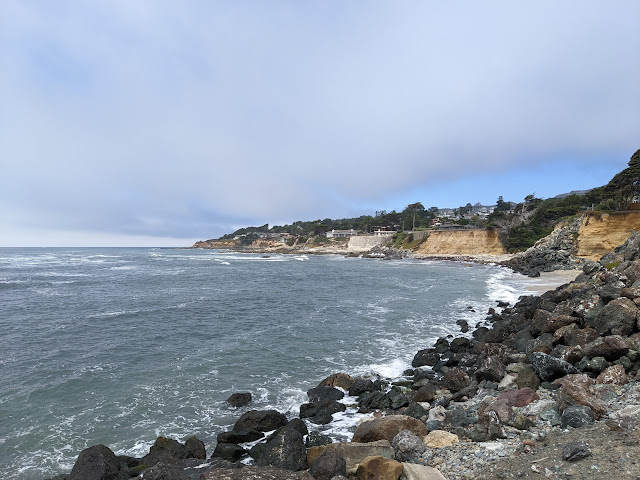
A scenery photo of clouds, rocks, Moss Beach, CA, and the Pacific Ocean. The photo was shot at Fitzgerald Marine Reserve in Moss Beach, CA.

A scenery photo of Mt. Diablo (in the distance), clouds, forest, and the San Francisco Bay Area. The photo was shot at Santa Clara Valley Vista Point on Skyline Blvd in San Mateo County, CA.

This is all the photos for today. I hope you have enjoyed viewing the photos! Please don't forget to share the blog post with your friends and family members! Also, if you want to get notifications when I post up more photos, "Like" us on Facebook or follow me on Instagram. These links can also be found on the top of the right sidebar.

Sunday, March 9, 2025

Don Edwards National Wildlife Refuge - Fremont, CA

On the 26th November 2024, my parents and I visited Alviso Marina County Park and the Alviso District in San Jose, CA, and Don Edwards National Wildlife Refuge in Fremont, CA. This was the first time I've headed to Alviso to see the salt flats, and it is amazing! I didn't know about Alviso until I saw photos from another photographer that I know. The photos are split into 2 blog posts. I hope you enjoy viewing my photos!

High Resolution Photos: If you want to see high resolution photos of any of the photos you see here, use the following links. If you wish to purchase prints of any of the photos, please contact me here. To see all of my photos from Don Edwards National Wildlife Refuge, use this link.

Parts: Alviso Marina County Park | Don Edwards National Wildlife Refuge

This blog post has my photos from Don Edwards National Wildlife Refuge in Fremont, CA. We decided to drop by for more cloud photos before heading home since it was on the route back. All the photos were shot on Shoreline Trail.

Message from the Photographer: Long COVID really slowed my photo processing, but I'm glad I can finally post these photos!

A scenery photo of clouds, San Francisco Bay, San Mateo-Hayward Bridge (US-92) (in the distance on the left), and San Francisco (in the distance on the right).
Approximate GPS location (type into Google): 37° 30' 52" N 122° 06' 36" W

A black and white process of the photo above.

A scenery photo of clouds, San Francisco Bay, San Francisco (in the distance), Sutro Tower & Twin Peaks (in the distance on the left), and Bay Bridge (in the distance on the right).
The photo was shot at the same spot as above.

A scenery photo of clouds, Dumbarton Bridge, power lines, peninsula (in the distance), and mountains (in the distance).
Approximate GPS location (type into Google): 37° 31' 00" N 122° 06' 35" W

A black and white process of the photo above.

A scenery photo of clouds, Dumbarton Bridge (left), power lines (left), peninsula (in the distance), and mountains (in the distance).
The photo was shot at the same spot as above.

A black and white process of the photo above.

A scenery photo of clouds, San Francisco Bay, and peninsula (in the distance).
The photo was shot at the same spot as above.

A black and white process of the photo above.

This is all the photos for today. I hope you have enjoyed viewing the photos! Please don't forget to share the blog post with your friends and family members! Also, if you want to get notifications when I post up more photos, "Like" us on Facebook or follow me on Instagram. These links can also be found on the top of the right sidebar.

Parts: Alviso Marina County Park | Don Edwards National Wildlife Refuge
Saturday, September 14, 2024

El Granada, CA (Cellphone Photos)

Today, on 14th September 2024, my parents and I went for a walk in El Granada, CA. The weather was very cloudy. The photos were shot on California Coastal Trail near Surfers' Beach. I hope you enjoy viewing my photos!

Message from the Photographer: I have actually not been anywhere for over a month now. I have been struggling with long COVID since November 2023, and I have been dealing with chronic fatigue and many other health problems. I haven't had the energy to go anywhere. Today, I had a little bit more energy than usual so I decided to go for a trip to Half Moon Bay and El Granada. I didn't bring any camera equipment with me (I have too little energy for that), but was able to take a few photos with my phone.

An overcast scenery photo of Pillar Point Air Force Station (left), the Pacific Ocean (left), California Coastal Trail (right), and State Route 1 (right). The photo was shot on California Coastal Trail near Surfers' Beach in El Granada, CA.

An overcast scenery photo of Surfers' Beach (slightly right from center), the Pacific Ocean (right), California Coastal Trail (left), and State Route 1 (left). The photo was shot on California Coastal Trail near Surfers' Beach in El Granada, CA.

An overcast scenery photo of Surfers' Beach, the Pacific Ocean (left), Pillar Point Air Force Station (left), and State Route 1 (right). The photo was shot on California Coastal Trail near Surfers' Beach in El Granada, CA.

This is all the photos for today. I hope you have enjoyed viewing the photos! Please don't forget to share the blog post with your friends and family members! Also, if you want to get notifications when I post up more photos, "Like" us on Facebook or follow me on Instagram. These links can also be found on the top of the right sidebar.

Saturday, June 24, 2023

Harbor Seals & Rabbits (Cellphone Photos) - San Mateo County, CA

On 23 June 2023, my mom and I took a trip to Fitzgerald Marine Reserve in Moss Beach, CA and Mavericks Beach in El Granada, CA. I took photos with my cellphone and mirrorless camera. The photos are split into 2 blog posts. I hope you enjoy viewing my photos!

Parts: Cellphone Photos | Olympus Photos

These wildlife photos were shot on my cellphone through my binoculars. The photos were shot at Fitzgerald Marine Reserve in Moss Beach, CA and the parking lot for Mavericks Beach in El Granada, CA.

Binoculars Used: Bushnell Engage X 10x42mm Binoculars (Product Link - Affiliate Link)

Message from the Photographer: You probably don't know how much I needed this trip. I have been sick for 6 weeks now, and I have been stuck at home. I suspect the "cold" I had the first 4 to 5 weeks was most likely a COVID-19 infection. You can read about my last update here when I took a short hiking trip in Sycamore Valley Regional Open Space Preserve in Danville, CA. I haven't really been out of the house much since May (except to buy food and groceries), and my exercise time outdoors is quite limited. Luckily I'm vaccinated, so the symptoms were relatively mild, but I still had a few fevers, headaches, and severe fatigue for a month. I have also been dealing with a moderate breakout of what seems to be eczema. It's causing mild rashes all over my body, with 2 problem areas that is really severe. I never had it this bad before. I have been feeling horrible and claustrophobic, but I seem to be getting better now. My energy level hasn't completely recovered yet. Really happy to have headed out to the coast for a day trip. I seem to have gotten all the claustrophobia out of my system for now.

A photo of Harbor Seals (Phoca vitulina), the beach, and the Pacific Ocean. The photo was shot at Fitzgerald Marine Reserve in Moss Beach, CA.
Binoculars Used: Bushnell Engage X 10x42mm Binoculars (Product Link - Affiliate Link)

A photo of Harbor Seals (Phoca vitulina), the beach, and the Pacific Ocean. The photo was shot at Fitzgerald Marine Reserve in Moss Beach, CA.
Binoculars Used: Bushnell Engage X 10x42mm Binoculars (Product Link - Affiliate Link)

A photo of Harbor Seals (Phoca vitulina) and the beach. The photo was shot at Fitzgerald Marine Reserve in Moss Beach, CA.
Binoculars Used: Bushnell Engage X 10x42mm Binoculars (Product Link - Affiliate Link)

A photo of Harbor Seals (Phoca vitulina), the beach, and the Pacific Ocean. The photo was shot at Fitzgerald Marine Reserve in Moss Beach, CA.
Binoculars Used: Bushnell Engage X 10x42mm Binoculars (Product Link - Affiliate Link)

A photo of a California Brush Rabbit (Sylvilagus bachmani), Cow Parsnip (Heracleum maximum), and Wild Radish (Raphanus raphanistrum). The photo was shot at the parking lot for Mavericks Beach in El Granada, CA.
Binoculars Used: Bushnell Engage X 10x42mm Binoculars (Product Link - Affiliate Link)

A photo of a California Brush Rabbit (Sylvilagus bachmani), Cow Parsnip (Heracleum maximum), and Wild Radish (Raphanus raphanistrum). The photo was shot at the parking lot for Mavericks Beach in El Granada, CA.
Binoculars Used: Bushnell Engage X 10x42mm Binoculars (Product Link - Affiliate Link)

This is all the photos for today. I hope you have enjoyed viewing the photos! Please don't forget to share the blog post with your friends and family members! Also, if you want to get notifications when I post up more photos, "Like" us on Facebook or follow me on Instagram. These links can also be found on the top of the right sidebar.

Parts: Cellphone Photos | Olympus Photos

Friday, April 5, 2019

Purisima Creek Redwoods & Forest of SF Bay Peninsula (Cellphone Shots)

Yesterday, April 4th, 2019, I had several hours to spare around the San Francisco Bay Area peninsula area. I had several hours between appointments with no plans at all. I explored the forest around the peninsula area (along State Route 35), and a tiny bit of Purisima Creek Redwoods Open Space Preserve. Here are the cellphone photos I took yesterday. This was a bit of a last minute decision so I didn't have a proper camera with me. I will definitely go back to the area soon with a proper camera.

Scenery from Upper Crystal Spring Reservoir Vista Point in Redwood City, CA near SR-35 (Skyline Blvd). The reservoir in the distance is Upper Crystal Springs Reservoir.

Scenery from Upper Crystal Spring Reservoir Vista Point in Redwood City, CA near SR-35 (Skyline Blvd). 

Scenery of mountains and forest shot on the side of SR-35 (Skyline Blvd) in Redwood City, CA.

 Scenery of the ocean towards Half Moon Bay, CA shot on the side of SR-35 (Skyline Blvd) in Redwood City, CA.

I think these are flowers of a wild blackberry plant. Photos shot on the side of SR-35 (Skyline Blvd) in Redwood City, CA.

Scenery photos of Coast Redwood (Sequoia sempervirens) forest shot on North Ridge Trail in Purisima Creek Redwoods Open Space Preserve in Redwood City, CA.

 Scenery photos of Coast Redwood (Sequoia sempervirens) forest shot on North Ridge Trail in Purisima Creek Redwoods Open Space Preserve in Redwood City, CA.

 Scenery of fog over a farm house shot from the park's north parking lot in Purisima Creek Redwoods Open Space Preserve in Redwood City, CA.

Unfortunately my hike at this park was cut very short due to weather. It was extremely foggy (I could feel it on my face), and because this was a last minute decision, I didn't have enough clothing on me and it was super cold. There were very strong winds at the top of the forest at the canopy level. I wasn't sure if it was raining or if the wind blew residual rain off the trees, but I got a bit wet. The trail was also pretty wet and somewhat slippery.

Scenery photos of the fog shot on the side of SR-35 (Skyline Blvd) in Redwood City, CA. 

Photo of a rock slide on SR-35 (Skyline Blvd) in Woodside, CA. 

This is all the photos for today. I hope you have enjoyed the photos! Please don't forget to share the blog post with your friends and family members! Also, if you want to get notifications when I post up more photos, "Like" us on Facebook or follow me on Twitter and Instagram. These links can also be found on the top of the right sidebar.